Image:Yagan-Belhus.png
From Wikipedia, the free encyclopedia
Size of this preview: 640 × 453 pixels
Full resolution (734 × 520 pixels, file size: 102 KB, MIME type: image/png)
| |
This is a file from the Wikimedia Commons. The description on its description page there is shown below. |
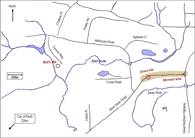
The is a map of the area in which Yagan died, located in the Perth, Western Australia suburb of Belhus. The map shows what is believed to be the approximate location of the grave, and the approximate area over which occurred the skirmish in which he was killed. The locations are taken from information provided by the Government of Western Australia's Department of Indigenous Affairs online Aboriginal Heritage Information System.
The map was hand-drawn by the uploader. This image replaced the lower quality image Image:Yagan-Belhus.jpg
|
|
Open this map in Google Earth. |
( Help| Source) |
According to this map, the approximate location of Yagan's burial is 31°46′49.38″S, 116°0′56.89″E - gobeirne 06:24, 26 June 2006 (UTC)
 |
I, the copyright holder of this work, hereby release it into the public domain. This applies worldwide. In case this is not legally possible: Afrikaans | Alemannisch | Aragonés | العربية | Asturianu | Български | Català | Cebuano | Česky | Cymraeg | Dansk | Deutsch | Eʋegbe | Ελληνικά | English | Español | Esperanto | Euskara | Estremeñu | فارسی | Français | Galego | 한국어 | हिन्दी | Hrvatski | Ido | Bahasa Indonesia | Íslenska | Italiano | עברית | Kurdî / كوردی | Latina | Lietuvių | Latviešu | Magyar | Македонски | Bahasa Melayu | Nederlands | Norsk (bokmål) | Norsk (nynorsk) | 日本語 | Polski | Português | Ripoarisch | Română | Русский | Shqip | Slovenčina | Slovenščina | Српски / Srpski | Suomi | Svenska | ไทย | Tagalog | Türkçe | Українська | Tiếng Việt | Walon | 中文(简体) | 中文(繁體) | zh-yue-hant | +/- |
File history
Click on a date/time to view the file as it appeared at that time.
| Date/Time | Dimensions | User | Comment | |
|---|---|---|---|---|
| current | 11:46, 11 January 2006 | 734×520 (102 KB) | Moondyne | (Map of Belhus, Western Australia showing gravesite of Yagan and and skirmish area. Hand-drawn by the uploader. (replaces previous jpg file of same name. new version has "noise" removed) {{PD-self}} ) |