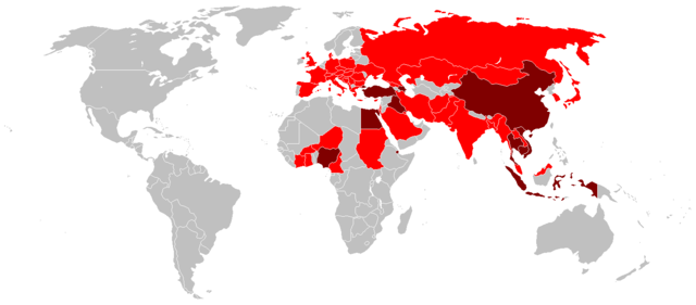
Image:Global spread of H5N1 map.PNG
From Wikipedia, the free encyclopedia

Size of this preview: 640 × 281 pixels
Full resolution (1,425 × 625 pixels, file size: 49 KB, MIME type: image/png)
File history
Click on a date/time to view the file as it appeared at that time.
| Date/Time | Dimensions | User | Comment | |
|---|---|---|---|---|
| current | 05:18, 15 May 2007 | 1,425×625 (49 KB) | Zntrip | (Added some countries listed on Wikipedia (Bangladesh and Ghana) removed Jordon) |
| 14:58, 6 March 2007 | 1,425×625 (31 KB) | Aivazovsky | ||
| 13:51, 5 February 2007 | 1,350×625 (30 KB) | Verdy p | (confirmed human death in Nigeria (see WHO report for 3 february 2007)) | |
| 23:50, 7 July 2006 | 1,350×625 (54 KB) | Zntrip | (Added Spain) | |
| 18:32, 23 May 2006 | 1,350×625 (54 KB) | Verdy p | (Import the 15 May update from English Wikipedia) | |
| 14:20, 2 May 2006 | 1,350×625 (54 KB) | Verdy p | (import the 27 April update from English wikipedia(adds Côte d'Ivoire)) | |
| 14:47, 6 April 2006 | 1,357×628 (31 KB) | Wangi | (Add UK) | |
| 02:03, 30 March 2006 | 800×370 (91 KB) | Cinik | (only update from en:, H5N1 confirmated in Czech republic) | |
| 05:36, 28 March 2006 | 1,357×628 (30 KB) | Verdy p | (Import depuis English Wikipedia) | |
| 09:11, 24 March 2006 | 1,357×628 (59 KB) | Verdy p | ||
| 08:43, 17 February 2006 | 1,357×628 (46 KB) | Shizhao | (== Summary == I made this map by using Image:BlankMap-World.png. Dark red areas have confirmed human cases and light red have bird cases, either in poultry or wild birds. – Zntrip 00:07, 16 February 2006 (UTC) == Licensing == {{GFDL-self) |
File links
The following pages on Schools Wikipedia link to this image (list may be incomplete):
