Image:Avian influenza spread map.jpg

From Wikipedia, the free encyclopedia
Wikimedia Commons logo This is a file from the Wikimedia Commons. The description on its description page there is shown below.
Commons is a freely licensed media file repository. You can help.

Summary

http://europa.eu.int/comm/health/ph_threats/com/Influenza/ai_recent_en.htm source: EUROPA Public Health

description

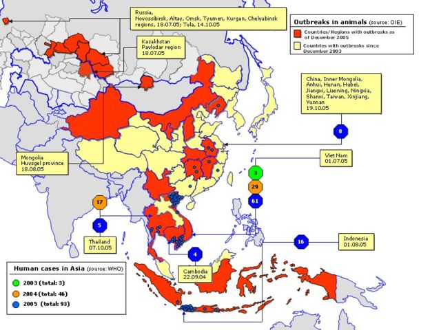
11 January 2006 map depicting the global spread of Avian Influenza through both animal and human populations.

Licensing

The copyright holder of this work allows anyone to use it for any purpose including unrestricted redistribution, commercial use, and modification.

Note:
If the image requires attribution, use {{ Attribution}} instead
If this is your own work, please consider using {{ PD-self}} instead.


العربية | Asturianu | Български | Česky | Dansk | Deutsch | English | Esperanto | Español | فارسی | Français | Galego | Italiano | 日本語 | 한국어 | Kurdî / كوردی | Nederlands | Polski | Português | Русский | Suomi | Svenska | Türkçe | ‪中文(简体)‬ | ‪中文(繁體)‬ | 粵語 | +/-

File history

Click on a date/time to view the file as it appeared at that time.

Date/Time Dimensions User Comment
current 11:51, 24 January 2006 800×600 (129 KB) Deeb (http://europa.eu.int/comm/health/ph_threats/com/Influenza/ai_recent_en.htm source: Europa Public Health ===description=== 11 January 2006 map depicting the global spread of Avian Influenza through both animal and human populations. [[Category:Avian flu)
The following pages on Schools Wikipedia link to this image (list may be incomplete):
The 2008 Wikipedia for Schools was sponsored by a UK Children's Charity, SOS Children UK , and is mainly selected from the English Wikipedia with only minor checks and changes (see www.wikipedia.org for details of authors and sources). See also our Disclaimer.