Image:Aral map.png
From Wikipedia, the free encyclopedia
No higher resolution available.
Aral_map.png (279 × 281 pixels, file size: 19 KB, MIME type: image/png)
| |
This is a file from the Wikimedia Commons. The description on its description page there is shown below. |
 |
This map image should be recreated using vector graphics as an SVG file. This has several advantages; see Commons:Media for cleanup for more information. If an SVG form of this image is already available, please upload it. After uploading an SVG, replace this template with {{ vector version available|new image name.svg}}. |
|
العربية | Български | Català | Česky | Dansk | Deutsch | English | Esperanto | Español | Français | Galego | 한국어 | Italiano | Magyar | Lietuvių | Nederlands | 日本語 | Polski | Português | Română | Русский | Suomi | Svenska | Türkçe | Українська | 中文(繁體) | 中文(简体) | +/- |
|
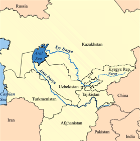
This is a map of area around the Aral Sea including the Amu Darya and Syr Darya rivers. I, Karl Musser, created it based on USGS data. The Aral Sea boundaries are circa 1960 but the political boundaries are the present-day ones. Countries that are at least partially in the Aral Sea watershed are in yellow.
|
File history
Click on a date/time to view the file as it appeared at that time.
| Date/Time | Dimensions | User | Comment | |
|---|---|---|---|---|
| current | 17:41, 9 April 2008 | 279×281 (19 KB) | Claus | |
| 14:02, 22 January 2007 | 300×300 (18 KB) | Kmusser | (added label for Naryn River) | |
| 18:52, 16 November 2005 | 300×300 (16 KB) | Kmusser | ||
| 18:33, 16 November 2005 | 300×300 (65 KB) | Kmusser | (This is a map of area around the Aral Sea including the Amu Darya and Syr Darya rivers. I, Karl Musser, created it based on USGS data. The Aral Sea b) |
File links
The following pages on Schools Wikipedia link to this image (list may be incomplete):
Categories: Maps of Turkmenistan