Image:AralSeaAug1964-keyhole.jpg
From Wikipedia, the free encyclopedia
No higher resolution available.
AralSeaAug1964-keyhole.jpg (450 × 450 pixels, file size: 35 KB, MIME type: image/jpeg)
| |
This is a file from the Wikimedia Commons. The description on its description page there is shown below. |
| Description |
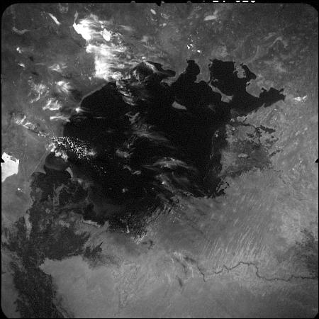
English: This image of the Aral Sea was acquired in August of 1964 by a United States Argon intelligence mapping/geodesy satellite.
KH-5 Mission 9064-A (incorrectly mislabeled 9066-A in the USGS archive) carried the A-22 mapping camera. A TAT-Agena carried this camera into an orbit of 114.96 degrees of inclination with a period of 84 minutes, a perigee of 219 degrees and an apogee of 232 degrees. International Launch Designation: 1964-043A Launch Date: August 21, 1964 Mission Duration: approximately 6 days |
|---|---|
| Source |
Transferred from en.wikipedia |
| Date |
2006-07-05 (original upload date) |
| Author |
Original uploader was Hartze11 at en.wikipedia |
| Permission ( Reusing this image) |
PD-USGOV.
|
License information
 |
This work is in the public domain in the United States because it is a work of the United States Federal Government under the terms of Title 17, Chapter 1, Section 105 of the US Code. See Copyright. Note: This only applies to works of the Federal Government and not to the work of any individual U.S. state, territory, commonwealth, county, municipality, or any other subdivision. This template also does not apply to postage stamps published by the United States Postal Service. (See 206.02(b) of Compendium II: Copyright Office Practices). العربية | Български | Česky | Deutsch | English | Español | Français | Magyar | Italiano | 日本語 | 한국어 | Polski | Português | 中文(繁體) | 中文(简体) | +/- |
 |
Original upload log
The original description page is/was here. All following user names refer to en.wikipedia.
- 2006-07-05 05:48 Hartze11 450×450×8 (35583 bytes) This image of the Aral Sea was acquired in August of 1964 by a United States intelligence mapping satellite.
File history
Click on a date/time to view the file as it appeared at that time.
| Date/Time | Dimensions | User | Comment | |
|---|---|---|---|---|
| current | 22:52, 10 January 2008 | 450×450 (35 KB) | File Upload Bot (Magnus Manske) | ( {{BotMoveToCommons|en.wikipedia}} {{Information |Description={{en|This image of the Aral Sea was acquired in August of 1964 by a United States Argon intelligence mapping/geodesy satellite. KH-5 Mission 9064-A (incorrectly mislabeled 9066-A in the USGS) |