Image:Sakura-jima from space.jpg
From Wikipedia, the free encyclopedia
Size of this preview: 387 × 479 pixels
Full resolution (3,000 × 3,716 pixels, file size: 3.15 MB, MIME type: image/jpeg)
| |
This is a file from the Wikimedia Commons. The description on its description page there is shown below. |
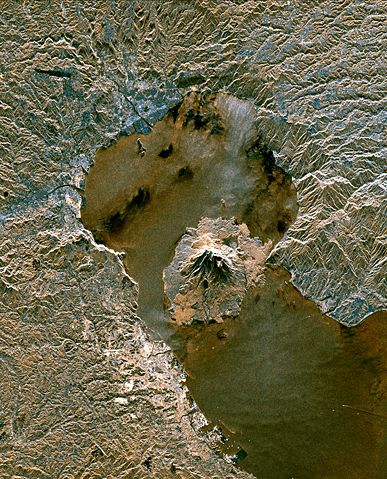
Sakurajima volcano from space
Original Caption Released with Image:
The active volcano Sakura-Jima on the island of Kyushu, Japan is shown in the center of this radar image. The volcano occupies the peninsula in the center of Kagoshima Bay, which was formed by the explosion and collapse of an ancient predecessor of today's volcano. The volcano has been in near continuous eruption since 1955. Its explosions of ash and gas are closely monitored by local authorities due to the proximity of the city of Kagoshima across a narrow strait from the volcano's centre, shown below and to the left of the central peninsula in this image. City residents have grown accustomed to clearing ash deposits from sidewalks, cars and buildings following Sakura-jima's eruptions. The volcano is one of 15 identified by scientists as potentially hazardous to local populations, as part of the international "Decade Volcano" program.
The image was acquired by the Spaceborne Imaging Radar-C/X-Band Synthetic Aperture Radar (SIR-C/X-SAR) onboard the space shuttle Endeavour on October 9, 1994. SIR-C/X-SAR, a joint mission of the German, Italian and the United States space agencies, is part of NASA's Mission to Planet Earth. The image is centered at 31.6 degrees North latitude and 130.6 degrees East longitude. North is toward the upper left. The area shown measures 37.5 kilometers by 46.5 kilometers (23.3 miles by 28.8 miles). The colors in the image are assigned to different frequencies and polarizations of the radar as follows: red is L-band vertically transmitted, vertically received; green is the average of L-band vertically transmitted, vertically received and C-band vertically transmitted, vertically received; blue is C-band vertically transmitted, vertically received.
Copied from en wiki
image description here
larger version here
Image courtesy: NASA/JPL-Caltech
 |
This file is in the public domain because it was created by NASA. NASA copyright policy states that "NASA material is not protected by copyright unless noted". ( NASA copyright policy page or JPL Image Use Policy). Deutsch | English | Español | Français | Galego | Nederlands | Português | Русский | 中文(简体) | 中文(繁體) | +/- |
|
 |
Warnings:
|
File history
Click on a date/time to view the file as it appeared at that time.
| Date/Time | Dimensions | User | Comment | |
|---|---|---|---|---|
| current | 14:53, 17 July 2007 | 3,000×3,716 (3.15 MB) | GDK | |
| 12:15, 16 October 2006 | 518×642 (114 KB) | Pazuzu | (Sakurajima volcano from space Copied from [http://en.wikipedia.org/wiki/Image:Sakura-jima_from_space.jpg en wiki] image description [http://photojournal.jpl.nasa.gov/catalog/PIA01777 here] larger version [http://photojournal.jpl.nasa.gov/jpeg/PIA01777.) |