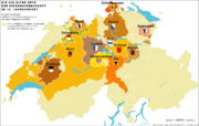
Image:Karte Zugewandte Orte.png
From Wikipedia, the free encyclopedia

Size of this preview: 640 × 406 pixels
Full resolution (1,200 × 761 pixels, file size: 257 KB, MIME type: image/png)
File history
Click on a date/time to view the file as it appeared at that time.
| Date/Time | Dimensions | User | Comment | |
|---|---|---|---|---|
| current | 09:09, 18 May 2008 | 1,200×761 (257 KB) | Sidonius | (neue Version, bessere Farben, andere Legende) |
| 19:13, 3 May 2007 | 1,200×761 (229 KB) | Sidonius | ({{Information |Description={{de|Die Zugewandten Orte der 13 «Alten Orte» (alte Kantone) der schweizerischen Eidgenossenschaft und ihr direkt beherrschtes Territorium im 18. Jahrhundert}} |Source=own work |Date=3.5.2007 |Au) |
File links
The following pages on Schools Wikipedia link to this image (list may be incomplete):

