From Wikipedia, the free encyclopedia
 |
This is a file from the Wikimedia Commons. The description on its description page there is shown below.Commons is a freely licensed media file repository. You can help.
|
Summary
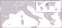
English: Location map for the Vatican City.
Español: Mapa de ubicación de la Ciudad del Vaticano.
Licensing
 |
This image has been (or is hereby) released into the public domain by its author, [[en:User:Vardion|]] at the English Wikipedia project. This applies worldwide.
In case this is not legally possible:
[[en:User:Vardion|]] grants anyone the right to use this work for any purpose, without any conditions, unless such conditions are required by law. |
|
A vector version of this image (SVG) is available.
It should be used in place of this raster image when superior.
Image:LocationVaticanCity.png  Image:LocationVaticanCity.svg Image:LocationVaticanCity.svg
For more information about vector graphics, read about Commons transition to SVG.
There is also information about MediaWiki's support of SVG images.
Deutsch | English | Español | Français | Galego | עברית | Magyar | Italiano | 日本語 | 한국어 | Lietuvių | Polski | Português | Русский | Српски / Srpski | Українська | +/- |
 |
File history
Click on a date/time to view the file as it appeared at that time.
|
|
Date/Time |
Dimensions |
User |
Comment |
| current |
04:57, 16 December 2004 |
250×115 (6 KB) |
EugeneZelenko |
|
File links
The following pages on Schools Wikipedia link to this image (list may be incomplete):


