Image:Is-wb-gs-gh v3.png
From Wikipedia, the free encyclopedia
Size of this preview: 299 × 479 pixels
Full resolution (1,428 × 2,289 pixels, file size: 259 KB, MIME type: image/png)
| |
This is a file from the Wikimedia Commons. The description on its description page there is shown below. |
SVG
| |
This map image was uploaded in a raster image format such as PNG, GIF, or JPEG. However, it contains information that could be stored more efficiently and/or accurately in the SVG format, as a vector graphic. If possible, please upload an SVG version of this image. After doing so, please replace all instances of the previous version throughout Wikipedia (noted under the “File links” header), tag the old version with {{ Vector version available|NewImage.svg}}, and remove this tag. For more information, see Wikipedia:Preparing images for upload. For assistance with converting to SVG, please see the Graphics Lab. |
 |
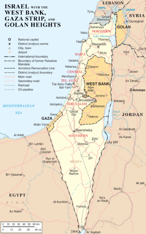
{{Information |Description=Map of Israel, the Palestinian territories (West Bank and Gaza Strip), the Golan Heights, and portions of neighbouring countries. Also United Nations deployment areas in countries adjoining Israel or Israeli-held territory, as of January 2004. |Source=Originally from en.wikipedia; description page is/was here.
(Original text : http://www.un.org/Depts/Cartographic/map/profile/israel.pdf (heavily modified)) |Date=2007-04-03 (original upload date)
(Original text : 3 April 2007) |Author=Original uploader was ChrisO at en.wikipedia
(Original text : [[:en:User:ChrisO) |Permission=Released into the public domain (by the author). |other_versions= }}
License information
 |
This image has been (or is hereby) released into the public domain by its author, ChrisO at the wikipedia project. This applies worldwide. In case this is not legally possible: |
| |
This image is a mapping derived from products of the United Nations Cartographic Section. Modified versions of UNCS maps may be used provided that the UN name and reference number does not appear on any modified version and a link to the original map is provided. Modified UN maps are to be considered in the public domain. This applies worldwide The UN maps is an open source material. You can use them to make your own maps. You do not need our permission for that. Please be advised that the UN name and reference number should not appear on any modified map. The UN map is a UN document and cannot be modified. You can say something like "Based on UN map number..." -- Vladimir Bessarabov (UNCS Cartographer), 13 April 05 |
 |
Original upload log
(All user names refer to en.wikipedia)
- 2007-04-03 22:53 ChrisO 1428×2289×8 (264824 bytes) == Summary == {{Information |Description= {{en|Map of [[Israel]], the [http://en.wikipedia.org/wiki/Palestinian_territories Palestinian territories] ([[West Bank]] and [[Gaza Strip]]), the [[Golan Heights]], and portions of neighbouring countries. Also [[
File history
Click on a date/time to view the file as it appeared at that time.
| Date/Time | Dimensions | User | Comment | |
|---|---|---|---|---|
| current | 08:22, 11 April 2007 | 1,428×2,289 (259 KB) | Liftarn | ({{Information |Description=Map of Israel, the Palestinian territories (West Bank and Gaza Strip), the Golan Heights, and portions of neighbouring countries. Also United Nations deployment areas in countries adjoining Israel or Israeli-held territory, as o) |