Image:2006 Serbia-CIA WFB Map.png
From Wikipedia, the free encyclopedia
No higher resolution available.
2006_Serbia-CIA_WFB_Map.png (328 × 352 pixels, file size: 16 KB, MIME type: image/png)
| |
This is a file from the Wikimedia Commons. The description on its description page there is shown below. |
| Description |
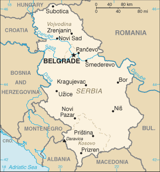
CIA World Factbook map from 2006. It shows Kosovo as an autonomous province of Serbia. Kosovo declared itself independence on February 17, 2008. This is recognized by the United States and some other nations. The most recent CIA World Factbook map, Image:Serbia-CIA WFB Map.png, shows Kosovo as an independent state. This image remain because of the ongoing dispute, and for historical purposes. |
|---|---|
| Source |
CIA World Factbook |
| Date |
29 June 2006 |
| Author |
United States Central Intelligence Agency |
| Permission ( Reusing this image) |
see below
|
 |
This image is in the public domain because it contains materials that originally came from the United States Central Intelligence Agency's World Factbook. Deutsch | English | Español | Français | 日本語 | Nederlands | 한국어 | Português | தமிழ் | Magyar | +/- |
 |
File history
Click on a date/time to view the file as it appeared at that time.
| Date/Time | Dimensions | User | Comment | |
|---|---|---|---|---|
| current | 13:27, 25 March 2008 | 328×352 (16 KB) | Superm401 | ({{Information |Description=CIA World Factbook map from 2006. It shows Serbia as an autonomous province of Serbia. Kosovo declared itself independence on February 17, 2008. This is recognized by the United States and some other nations. The most recent) |
File links
The following pages on Schools Wikipedia link to this image (list may be incomplete):