From Wikipedia, the free encyclopedia
 |
This is a file from the Wikimedia Commons. The description on its description page there is shown below.Commons is a freely licensed media file repository. You can help.
|
 |
This is a featured picture, which means that members of the community have identified it as one of the finest images on the English Wikipedia, adding significantly to its accompanying article. If you have a different image of similar quality, be sure to upload it using the proper free license tag, add it to a relevant article, and nominate it. |
 |
This image was selected as picture of the day on the English Wikipedia for September 10, 2008. |
 |
This is a featured picture on English Wikipedia and is considered one of the finest images.
- If you think this file should be featured on Wikimedia Commons as well, feel free to nominate it.
- If you have an image of similar quality that can be published under a suitable copyright license, be sure to upload it, tag it, and nominate it.
|
 |
 |
This vector image was created with Inkscape. |
| Camera location Gibraltar map-en-edit2.svg |
36°08′00″N, 5°21′00″W 36.1333333333;-5.35 |
This and other geocoded Commons images:
|
( Info) |
| Description |
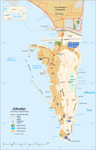
Map in English of Gibraltar |
| Source |
adapted from: Image:Gibraltar map-en.svg
Map created using screenshots of Google Earth satellite imagery from a point of view located at 1.18 km of altitude (available imagery of November 2007) ;
Other references :
* CIA map ;
* Gibnet map ;
* U.K. MoD map
Locator map : Image:Blank_map_of_South_Europe_and_North_Africa.svg (modified) created by Historicair ;
Approximate scale : 1:40,000 (accuracy : about 10 m)
Note : The roads width is proportional to reality |
| Date |
November 2007 |
| Author |
Original by Eric Gaba ( Sting), label/legend edits by Jeff Dahl |
Permission
( Reusing this image) |
Attribution and Share-Alike required |
| Other versions |
Español, Français |
Français :
- Sujet : Carte en anglais de Gibraltar ;
- Sources : Création personnelle ;
-
- Carte créée à partir de captures d'écran d'images satellite de Google Earth d'un point de vue placé à 1,18 km d'altitude (imagerie disponible de novembre 2007) ;
- Références complémentaires :
-
- Carte du Ministère de la Défense britannique ;
- Carte de localisation : Image:Blank_map_of_South_Europe_and_North_Africa.svg (modifiée) crée par Historicair ;
- Échelle approximative : 1:40 000 (précision : environ 10 m) ;
- Note : Largeur du tracé des routes proportionnelle à la réalité ;
- Auteur : Eric Gaba ( fr:Sting) ;
- Date : Novembre 2007.
 |
This SVG file uses embedded text that can be easily translated into your language. Learn more. For SVG images, you can use this page to translate it into your language.
العربية | Català | Dansk | Deutsch | English | Esperanto | Español | Français | Galego | Italiano | 日本語 | Lietuvių | Magyar | Nederlands | Polski | Português | Русский | Svenska | Українська | +/- |
Licensing
I, the copyright holder of this work, hereby publish it under the following licenses:
 |
Permission is granted to copy, distribute and/or modify this document under the terms of the GNU Free Documentation license, Version 1.2 or any later version published by the Free Software Foundation; with no Invariant Sections, no Front-Cover Texts, and no Back-Cover Texts. A copy of the license is included in the section entitled " GNU Free Documentation license".
Aragonés | العربية | Asturianu | Беларуская (тарашкевіца) | Български | বাংলা | ইমার ঠার/বিষ্ণুপ্রিয়া মণিপুরী | Brezhoneg | Bosanski | Català | Cebuano | Česky | Dansk | Deutsch | Ελληνικά | English | Esperanto | Español | Eesti | Euskara | فارسی | Suomi | Français | Gaeilge | Galego | עברית | Hrvatski | Magyar | Bahasa Indonesia | Ido | Íslenska | Italiano | 日本語 | ქართული | ភាសាខ្មែរ | 한국어 | Kurdî / كوردی | Latina | Lëtzebuergesch | Lietuvių | Bahasa Melayu | Nnapulitano | Nederlands | Norsk (nynorsk) | Norsk (bokmål) | Occitan | Polski | Português | Română | Русский | Slovenčina | Slovenščina | Shqip | Српски / Srpski | Svenska | తెలుగు | ไทย | Tagalog | Türkçe | Українська | اردو | Tiếng Việt | Volapük | Yorùbá | 中文(简体) | 中文(繁體) | +/- |
You may select the license of your choice.
|
File history
Click on a date/time to view the file as it appeared at that time.
|
|
Date/Time |
Dimensions |
User |
Comment |
| current |
18:52, 11 December 2007 |
1,000×1,558 (1.79 MB) |
Jeff Dahl |
|
|
|
17:08, 10 December 2007 |
1,200×1,870 (1.78 MB) |
Jeff Dahl |
|
File links
The following pages on Schools Wikipedia link to this image (list may be incomplete):


