Image:Continental West Germanic languages.png
From Wikipedia, the free encyclopedia
Size of this preview: 412 × 479 pixels
Full resolution (1,028 × 1,196 pixels, file size: 138 KB, MIME type: image/png)
| |
This is a file from the Wikimedia Commons. The description on its description page there is shown below. |
 |
This map has been uploaded by Electionworld from en.wikipedia.org to enable the |
Summary
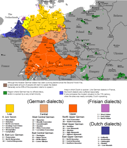
The dialectal ranges (not those of standard languages!) of the Continental West Germanic languages (Dutch/Frisian/German) Rex 12:31, 23 September 2006 (UTC)
The colours and shades in this map do not reflect the actual relationship between dialects or languages. Sundar1 13:07, 01 June 2007 (UTC)
There's a typo in the key where number 28 occurs twice. - 91.89.99.169 18:36, 29 December 2007 (UTC)
Licensing
 |
I, the copyright holder of this work, hereby release it into the public domain. This applies worldwide. In case this is not legally possible: Afrikaans | Alemannisch | Aragonés | العربية | Asturianu | Български | Català | Cebuano | Česky | Cymraeg | Dansk | Deutsch | Eʋegbe | Ελληνικά | English | Español | Esperanto | Euskara | Estremeñu | فارسی | Français | Galego | 한국어 | हिन्दी | Hrvatski | Ido | Bahasa Indonesia | Íslenska | Italiano | עברית | Kurdî / كوردی | Latina | Lietuvių | Latviešu | Magyar | Македонски | Bahasa Melayu | Nederlands | Norsk (bokmål) | Norsk (nynorsk) | 日本語 | Polski | Português | Ripoarisch | Română | Русский | Shqip | Slovenčina | Slovenščina | Српски / Srpski | Suomi | Svenska | ไทย | Tagalog | Türkçe | Українська | Tiếng Việt | Walon | 中文(简体) | 中文(繁體) | zh-yue-hant | +/- |
File history
Click on a date/time to view the file as it appeared at that time.
| Date/Time | Dimensions | User | Comment | |
|---|---|---|---|---|
| current | 16:00, 1 August 2008 | 1,028×1,196 (138 KB) | Gruna 1 | ({{Information |Description=new version: more specific in the Netherlands |Source=new version of the old map |Date=1st august 2008 |Author=Electionworld |Permission=see below |other_versions= }}) |
| 22:21, 22 December 2006 | 1,028×1,196 (131 KB) | Electionworld | ({{ew|en|Rex Germanus}} == Summary == The dialectal ranges (not those of standard languages!) of the Continental West Germanic languages (Dutch/Frisian/German) Rex 12:31, 23 September 2006 (UTC) == Licensing == {{PD-self}} ) |