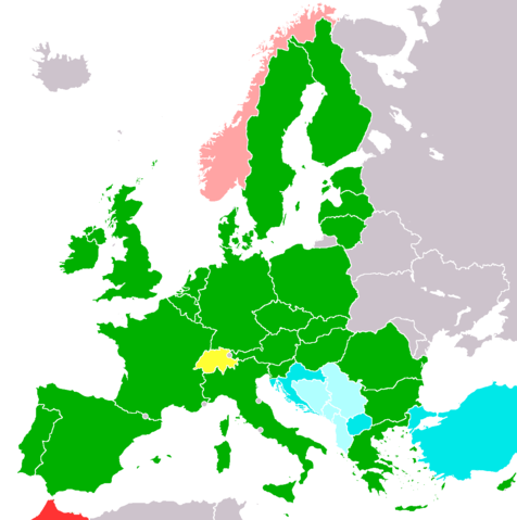
Image:European Union member states with applications.png
From Wikipedia, the free encyclopedia

Size of this preview: 476 × 479 pixels
Full resolution (1,236 × 1,245 pixels, file size: 33 KB, MIME type: image/png)
File history
Click on a date/time to view the file as it appeared at that time.
| Date/Time | Dimensions | User | Comment | |
|---|---|---|---|---|
| current | 12:49, 1 August 2008 | 1,236×1,245 (33 KB) | Rokerismoravee | (Reverted to version as of 14:14, 9 June 2008) |
| 11:26, 12 June 2008 | 1,236×1,245 (81 KB) | Cradel | (+KOS, gave source on user's talk page) | |
| 14:14, 9 June 2008 | 1,236×1,245 (33 KB) | Milosevo | (again: revert, vandalism. Do you have a source?) | |
| 20:15, 8 June 2008 | 1,236×1,245 (81 KB) | Cradel | (Reverted to version as of 18:37, 25 February 2008) | |
| 15:24, 8 June 2008 | 1,236×1,245 (33 KB) | Milosevo | (Reverted to version as of 03:45, 17 May 2007) | |
| 18:37, 25 February 2008 | 1,236×1,245 (81 KB) | Hoshie | (fixed Gibraltar, Ceuta and Melilla, and the SBAs) | |
| 00:09, 24 February 2008 | 1,236×1,245 (81 KB) | Hoshie | (added Kosovo after a requst ) | |
| 03:45, 17 May 2007 | 1,236×1,245 (33 KB) | Tene | (Optimised (0;r)) | |
| 11:06, 28 December 2006 | 1,236×1,245 (81 KB) | Nightstallion | ||
| 09:17, 19 June 2006 | 1,236×1,245 (81 KB) | Nightstallion | (partial revert to Hoshie, some changes were good :)) | |
| 15:21, 17 June 2006 | 1,236×1,245 (81 KB) | Nightstallion | (Reverted to earlier revision) | |
| 10:09, 17 June 2006 | 1,236×1,245 (81 KB) | Hoshie | (I have fixed the map to add a purple colour for OCTs in Europe. Ceuta, Melilla, and the various islands have been added based on the CIA Factbook map of Spain. A pixel has been added for Gibraltar) | |
| 02:21, 14 June 2006 | 1,236×1,245 (81 KB) | Hoshie | (The EU map has been fixed to show the SBAs on Cyprus, Isle of Man, Jersey, and Guernsey are NOT in the EU. My mod is under same license as the orginal) | |
| 05:49, 26 May 2006 | 1,236×1,245 (81 KB) | Nightstallion | (separate Serbia and Montenegro, done by en:User:Kseferovic) | |
| 08:46, 17 May 2006 | 1,236×1,245 (56 KB) | Nightstallion | (better colours) | |
| 20:29, 28 April 2006 | 1,236×1,245 (143 KB) | Nightstallion | (enlarge microstates to recognizable size) | |
| 17:08, 13 February 2006 | 1,236×1,245 (142 KB) | Nightstallion | (better map) | |
| 11:30, 29 January 2006 | 262×160 (36 KB) | Nightstallion | (distinguish between Morocco and Norway) | |
| 12:20, 21 January 2006 | 262×160 (37 KB) | Nightstallion | (Based on w:Image:CrudeEU27.png, placeholder for better image to be based on Image:SchengenAgreement_map.png. ~~~~) |
File links
The following pages on Schools Wikipedia link to this image (list may be incomplete):
Categories: Maps of the European Union
