Image:PearlHarborCarrierChart.jpg
From Wikipedia, the free encyclopedia
Size of this preview: 640 × 453 pixels
Full resolution (1,004 × 710 pixels, file size: 213 KB, MIME type: image/jpeg)
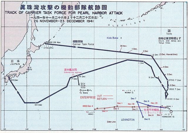
Public Domain chart from "Reports of General MacArthur, prepared by his General Staff." This book was printed by GPO. The chart shows the routes of the Japanese attack force to and from Pearl Harbour. I have added the routes of the two American carriers.
Note that dates/times of the Japanese fleet location are given as Japan time, not local. (e.g., Dec 8 0130 shown is Dec 7 0600 local time in Hawaii.)
 |
This work is in the public domain in the United States because it is a work of the United States Federal Government under the terms of Title 17, Chapter 1, Section 105 of the US Code. See Copyright. Note: This only applies to works of the Federal Government and not to the work of any individual U.S. state, territory, commonwealth, county, municipality, or any other subdivision. This template also does not apply to postage stamps published by the United States Postal Service after 1978. (See 206.02(b) of Compendium II: Copyright Office Practices). |
 |
| |
This file is an exact duplicate of another file from the Wikimedia Commons. Unless it is currently protected from editing, this media file may qualify for speedy deletion if it satisfies these conditions. | |
File history
Click on a date/time to view the file as it appeared at that time.
| Date/Time | Dimensions | User | Comment | |
|---|---|---|---|---|
| current | 22:33, 20 July 2008 | 1,004×710 (213 KB) | Hohum ( Talk | contribs) | (Reverted to version as of 18:27, 10 October 2004. Edit was far too harsh on contrast and more difficult to read.) |
| revert | 20:43, 8 June 2007 | 1,004×710 (335 KB) | Reddi ( Talk | contribs) | |
| revert | 18:27, 10 October 2004 | 1,004×710 (213 KB) | Main Balrog ( Talk | contribs) | (Public Domain chart from " Reports of General MacArthur, prepared by his General Staff." This book was printed by GPO. The chart shows the routes of the Japanese attack force to and from Pearl Harbour. I have added the routes of the two American carriers) |
See the setup instructions for more information.
File links
The following file is a duplicate of this file:
The following pages on Schools Wikipedia link to this image (list may be incomplete):
Categories: United States government images