From Wikipedia, the free encyclopedia
 Size of this preview: 364 × 479 pixels
 Full resolution (1,385 × 1,824 pixels, file size: 919 KB, MIME type: image/png)
 |
This is a file from the Wikimedia Commons. The description on its description page there is shown below.Commons is a freely licensed media file repository. You can help.
|
Summary
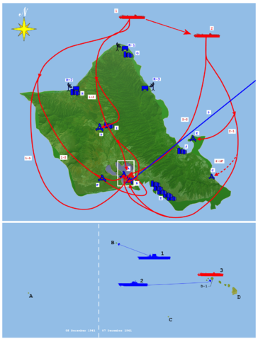
| Description |
Top:
A. Ford Island NAS
B. Hickam Field
C. Bellows Field
D. Wheeler Field
E. Kaneohe NAS
F. Ewa MCAS
R-1. Opana Radar Station
R-2. Kawailoa RS
R-3. Kaaawa RS
G. Haleiwa
H. Kahuku
I. Wahiawa
J. Kaneohe
K. Honolulu
0. B-17s from mainland
1. First strike group
1-1. Level bombers
1-2. Torpedo bombers
1-3. Dive bombers
2. Second strike group
2-1. Level bombers
2-1F. Fighters
2-2. Dive bombers
Bottom:
A. Wake Island
B. Midway Islands
C. Johnston Island
D. Hawaii
D-1. Oahu
1. USS Lexington
2. USS Enterprise
3. First Air Fleet
|
| Source |
self-made |
| Date |
02:42, 16 November 2007 (UTC) |
| Author |
Anynobody |
Permission
( Reusing this image) |
see below
|
References: Image:Pearl Harbour bombings map.jpg - Japanese map of attacks
Army map of military facilities on Oahu
Licensing
I, the copyright holder of this work, hereby publish it under the following licenses:
 |
Permission is granted to copy, distribute and/or modify this document under the terms of the GNU Free Documentation license, Version 1.2 or any later version published by the Free Software Foundation; with no Invariant Sections, no Front-Cover Texts, and no Back-Cover Texts. A copy of the license is included in the section entitled " GNU Free Documentation license".
Aragonés | العربية | Asturianu | Беларуская (тарашкевіца) | Български | বাংলা | ইমার ঠার/বিষ্ণুপ্রিয়া মণিপুরী | Brezhoneg | Bosanski | Català | Cebuano | Česky | Dansk | Deutsch | Ελληνικά | English | Esperanto | Español | Eesti | Euskara | فارسی | Suomi | Français | Gaeilge | Galego | עברית | Hrvatski | Magyar | Bahasa Indonesia | Ido | Íslenska | Italiano | 日本語 | ქართული | ភាសាខ្មែរ | 한국어 | Kurdî / كوردی | Latina | Lëtzebuergesch | Lietuvių | Bahasa Melayu | Nnapulitano | Nederlands | Norsk (nynorsk) | Norsk (bokmål) | Occitan | Polski | Português | Română | Русский | Slovenčina | Slovenščina | Shqip | Српски / Srpski | Svenska | తెలుగు | ไทย | Tagalog | Türkçe | Українська | اردو | Tiếng Việt | Volapük | Yorùbá | 中文(简体) | 中文(繁體) | +/- |
You may select the license of your choice.
|
File history
Click on a date/time to view the file as it appeared at that time.
|
|
Date/Time |
Dimensions |
User |
Comment |
| current |
02:42, 16 November 2007 |
1,385×1,824 (919 KB) |
Anynobody |
|
File links
The following pages on Schools Wikipedia link to this image (list may be incomplete):