Image:LocationIndia.png
From Wikipedia, the free encyclopedia
Size of this preview: 640 × 282 pixels
Full resolution (1,427 × 628 pixels, file size: 103 KB, MIME type: image/png)
| |
This is a file from the Wikimedia Commons. The description on its description page there is shown below. |
Summary
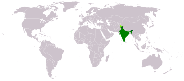
Location map for w:India.
User:dbenbenn modified Image:BlankMap-World.png.
Licensing
 |
This image has been (or is hereby) released into the public domain by its author, Vardion at the English Wikipedia project. This applies worldwide. In case this is not legally possible: |
File history
Click on a date/time to view the file as it appeared at that time.
| Date/Time | Thumbnail | Dimensions | User | Comment | |
|---|---|---|---|---|---|
| current | 03:16, 1 May 2008 |  |
1,427×628 (103 KB) | KAVO | ((Changed to colours more noticeable: *Light green - Claimed by India, not administered by India **(Aksai Chin, Azad Kashmir, Northern Areas, Shaksgam Valley) *Deep Green - Disputed with other nations, administered by India **(Arunachal Pradesh, Jammu and ) |
| 09:17, 3 June 2005 |  |
1,357×628 (24 KB) | Nichalp | (NPOV map, please discuss any changes with me for NPOV status) | |
| 22:39, 12 February 2005 |  |
1,357×628 (21 KB) | Dbenbenn | (higher resolution version, without black border) | |
| 20:28, 5 December 2004 |  |
250×115 (18 KB) | EugeneZelenko | (Location map for India.<br/>Originally created for English Wikipedia by Vardion.<br/>{{GFDL}}) |
File links
The following pages on Schools Wikipedia link to this image (list may be incomplete):