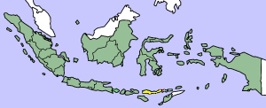
Image:Flores map.png

From Wikipedia, the free encyclopedia
Wikimedia Commons logo This is a file from the Wikimedia Commons. The description on its description page there is shown below.
Commons is a freely licensed media file repository. You can help.

This image was copied from wikipedia:en. The original description was:

Map showing Flores Island within Indonesia

Public domain This file has been released into the public domain by the copyright holder, its copyright has expired, or it is ineligible for copyright. This applies worldwide.
Warning sign Note: This tag is obsolete! Nothing is public domain without a reason. Don't use this generic template - please use instead:
  • {{ PD-old}} (for works out of copyright where the author has been dead for over 70 years),
  • {{ PD-Art}} (for photos of old paintings and art out of copyright),
  • {{ PD-ineligible}} (for trivial work),
  • {{ PD-USGov}} (for work by the U.S. federal government),
  • {{ PD-self}} (if the uploader and creator releases the rights),
  • {{ PD-user|user}} (if another user released his/her rights), or {{ Copyrighted free use}}.
    • use {{ PD-user-w| projectcode|projectname|username}} for users with no account on Commons.
  • {{ PD-author|Author's name}} - for works released into the public domain by non-Wikimedia users.
  • If the work is PD for another reason, check the copyright tag page or use {{ PD-because|reason}}.

العربية | Български | Česky | Deutsch | English | Español | Français | हिन्दी | Italiano | 日本語 | ‪Norsk (bokmål)‬ | ‪Norsk (nynorsk)‬ | Polski | Português | Русский | Slovenčina | Slovenščina | Српски / Srpski | Türkçe | 中文 | +/-

date/time username edit summary
14:17, 14 March 2005 *drew (Map showing Flores Island within Indonesia {{PD}})

File history

Click on a date/time to view the file as it appeared at that time.

Date/Time Dimensions User Comment
current 10:19, 2 February 2007 300×122 (21 KB) J. Patrick Fischer (The original image was copied from wikipedia:en. The image was corrected by user:J. Patrick Fischer (two islands east of Flores were wrong marked as part of Flores before). The original description was: Map showing Flores Island within Indonesia {{)
12:26, 10 October 2006 300×122 (16 KB) UtherSRG (Change colour.)
12:27, 5 October 2005 300×122 (15 KB) ChongDae (This image was copied from wikipedia:en. The original description was: Map showing Flores Island within Indonesia {{PD}} {| border="1" ! date/time || username || edit summary |---- | 14:17, 14 March 2005 || *drew || <nowiki>(Map showing Flores Island wi)
The following pages on Schools Wikipedia link to this image (list may be incomplete):
This Wikipedia DVD Selection has a sponsor: SOS Children , and is mainly selected from the English Wikipedia with only minor checks and changes (see www.wikipedia.org for details of authors and sources). See also our Disclaimer.