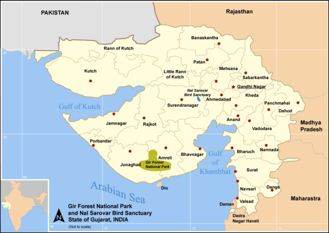
Image:Map Guj Nat Parks Sanctuary.png
From Wikipedia, the free encyclopedia
Size of this preview: 640 × 453 pixels
Full resolution (1,058 × 749 pixels, file size: 67 KB, MIME type: image/png)
| |
This is a file from the Wikimedia Commons. The description on its description page there is shown below. |
Summary
National parks and Sanctuary - Gujarat State (India) with district boundries and city marks - Self Made - w:User:Miljoshi - Jan 2006
- w:Gir Forest National Park - w:Nal Sarovar Bird Sanctuary
Note: co-ordinates are estimated, and may not be exactly accurate.
Other version available : SVG map in French by Sting :
 A vector version of this image (SVG) is available. For more information about vector graphics, read about Commons transition to SVG. Deutsch | English | Español | Français | Galego | עברית | Magyar | Italiano | 日本語 | 한국어 | Lietuvių | Polski | Português | Русский | Српски / Srpski | Українська | +/- |
 |
Licensing
|

File history
Click on a date/time to view the file as it appeared at that time.
| Date/Time | Dimensions | User | Comment | |
|---|---|---|---|---|
| current | 15:50, 1 January 2006 | 1,058×749 (67 KB) | Miljoshi | (National parks and Sanctuary - Gujarat State (India) with district boundries and city marks - Self Made - w:User:Miljoshi - Jan 2006 - w:Gir Forest National Park - w:Nal Sarovar Bird Sanctuary Note: co-ordinates are estimated, and may not be) |