Image:1984 fictious world map v2 quad.svg
From Wikipedia, the free encyclopedia
1984_fictious_world_map_v2_quad.svg (SVG file, nominally 2,212 × 1,123 pixels, file size: 1.28 MB)
| |
This is a file from the Wikimedia Commons. The description on its description page there is shown below. |
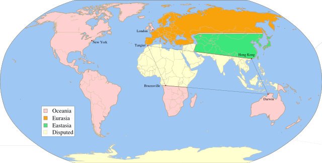
Summary
| Description |
Fictitious map, illustrating the political landscape of Orwell's Nineteen Eighty-Four, based on Image:1984_fictious_world_map_v2_quad.png, rendered from Image:1984_fictious_world_map_v2.svg, inspired by Image:1984_fictious_world_map.png and Image:1984_Orwell_arrows_2.png, based on Image:BlankMap-World6.svg, created following Wikipedia's map colour standard. |
||
|---|---|---|---|
| Source |
Twisp |
||
| Date |
March 21, 2008 |
||
| Author |
MichaelsProgramming |
||
| Permission ( Reusing this image) |
|
Licensing
 |
I, the copyright holder of this work, hereby release it into the public domain. This applies worldwide. In case this is not legally possible: Afrikaans | Alemannisch | Aragonés | العربية | Asturianu | Български | Català | Cebuano | Česky | Cymraeg | Dansk | Deutsch | Eʋegbe | Ελληνικά | English | Español | Esperanto | Euskara | Estremeñu | فارسی | Français | Galego | 한국어 | हिन्दी | Hrvatski | Ido | Bahasa Indonesia | Íslenska | Italiano | עברית | Kurdî / كوردی | Latina | Lietuvių | Latviešu | Magyar | Македонски | Bahasa Melayu | Nederlands | Norsk (bokmål) | Norsk (nynorsk) | 日本語 | Polski | Português | Ripoarisch | Română | Русский | Shqip | Slovenčina | Slovenščina | Српски / Srpski | Suomi | Svenska | ไทย | Tagalog | Türkçe | Українська | Tiếng Việt | Walon | 中文(简体) | 中文(繁體) | zh-yue-hant | +/- |
File history
Click on a date/time to view the file as it appeared at that time.
| Date/Time | Dimensions | User | Comment | |
|---|---|---|---|---|
| current | 03:42, 22 March 2008 | 2,212×1,123 (1.28 MB) | MichaelsProgramming | ({{Information |Description=Fictitious map, illustrating the political landscape of Orwell's [http://en.wikipedia.org/wiki/Nineteen_Eighty-Four Nineteen Eighty-Four], based on Image:1984_fictious_world_map_v2_quad.png, rendered from [[:Image:1984_fict) |