Image:Meningite.png

From Wikipedia, the free encyclopedia

Wikimedia Commons logo This is a file from the Wikimedia Commons. The description on its description page there is shown below.
Commons is a freely licensed media file repository. You can help.
Description
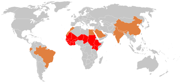
Français : Pays concernés par la fr:méningite. Cette répartition géographique ne reflète pas entièrement le risque car tous les pays du globe sont concernés par cette maladie (à preuve les cas réguliers décrits en France par exemple). Cette carte a néanmoins le mérite de mettre en exergue la ceinture de la méningite en Afrique où tous les ans il existe une épidémie importante en fin de saison sèche.
English: Countries with reported cases of en:meningitis. This map does not entirely reflect the risk posed by meningitis, because there are isolated cases reported around the world each year. This map does show the epidemic "belt of meningitis" in Africa that occurs every year at the end of the dry season.
Source
Date

2006-09-27

Author

Percherie

Permission
( Reusing this image)

Voir ci-dessous


 Ceinture méningitique ("Meningitis belt")
 Zones endémique (epidemic zones)
 Zones endémosporadique (sporadic cases)

Licensing

I, the copyright holder of this work, hereby publish it under the following licenses:
GNU head Permission is granted to copy, distribute and/or modify this document under the terms of the GNU Free Documentation license, Version 1.2 or any later version published by the Free Software Foundation; with no Invariant Sections, no Front-Cover Texts, and no Back-Cover Texts. A copy of the license is included in the section entitled " GNU Free Documentation license".

Aragonés | العربية | Asturianu | Беларуская (тарашкевіца) | Български | বাংলা | ইমার ঠার/বিষ্ণুপ্রিয়া মণিপুরী | Brezhoneg | Bosanski | Català | Cebuano | Česky | Dansk | Deutsch | Ελληνικά | English | Esperanto | Español | Eesti | Euskara | فارسی | Suomi | Français | Gaeilge | Galego | עברית | Hrvatski | Magyar | Bahasa Indonesia | Ido | Íslenska | Italiano | 日本語 | ქართული | ភាសាខ្មែរ | 한국어 | Kurdî / كوردی | Latina | Lëtzebuergesch | Lietuvių | Bahasa Melayu | Nnapulitano | Nederlands | ‪Norsk (nynorsk)‬ | ‪Norsk (bokmål)‬ | Occitan | Polski | Português | Română | Русский | Slovenčina | Slovenščina | Shqip | Српски / Srpski | Svenska | తెలుగు | ไทย | Tagalog | Türkçe | Українська | اردو | Tiếng Việt | Volapük | Yorùbá | ‪中文(简体)‬ | ‪中文(繁體)‬ | +/-

Some rights reserved
Creative Commons Attribution icon Creative Commons Share Alike icon
This file is licensed under the Creative Commons Attribution ShareAlike license versions 2.5, 2.0, and 1.0

العربية | Български | Català | Česky | Dansk | Deutsch | English | Español | Euskara | فارسی | Français | Galego | עברית | Italiano | 日本語 | 한국어 | Lietuvių | Nederlands | Polski | Português | Русский | Svenska | தமிழ் | తెలుగు | Türkçe | 中文 | 中文 | +/-

You may select the license of your choice.

File history

Click on a date/time to view the file as it appeared at that time.

Date/Time Dimensions User Comment
current 21:54, 28 September 2006 1,357×628 (29 KB) Percherie (Cette répartition géographique ne reflète pas entièrement le risque car tous les pays du globe sont concernés par cette maladie (à preuve les cas réguliers décrits en France par exemple). Cette carte a néanmoins le mérite de mettre en exergue la)
The following pages on Schools Wikipedia link to this image (list may be incomplete):
This Wikipedia DVD Selection is sponsored by SOS Children , and is mainly selected from the English Wikipedia with only minor checks and changes (see www.wikipedia.org for details of authors and sources). See also our Disclaimer.