Image:Glasgow-Subway-Map.png

From Wikipedia, the free encyclopedia
Wikimedia Commons logo This is a file from the Wikimedia Commons. The description on its description page there is shown below.
Commons is a freely licensed media file repository. You can help.

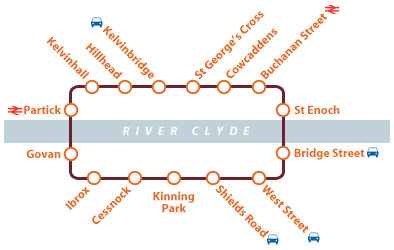
English A map of the Glasgow Subway. By David Arthur.

Français Un plan du métro de Glasgow. Par David Arthur.

A vector version of this image (SVG) is available.
It should be used in place of this raster image when superior.


Image:Glasgow-Subway-Map.png    Image:Glasgow_SPT_Subway_Map.svg

For more information about vector graphics, read about Commons transition to SVG.
There is also information about MediaWiki's support of SVG images.


Deutsch | English | Español | Français | Galego | עברית | Magyar | Italiano | 日本語 | 한국어 | Lietuvių | Polski | Português | Русский | Српски / Srpski | Українська | +/-

New SVG image
Creative Commons License
Creative Commons Attribution icon Creative Commons Share Alike icon
This file is licensed under the Creative Commons " Attribution ShareAlike 2.0 Canada" Licence

Ce fichier est sous la licence de Creative Commons suivante «  Paternité – Partage des Conditions Initiales à l'Identique 2.0 Canada »

File history

Click on a date/time to view the file as it appeared at that time.

Date/Time Dimensions User Comment
current 22:59, 18 September 2005 394×250 (9 KB) DavidArthur ( English A map of the en:Glasgow Subway. By David Arthur. Français Un plan du fr:métro de Glasgow. Par David Arthur. {{Cc-by-sa-2.0-ca}} Category:Subway maps)
The following pages on Schools Wikipedia link to this image (list may be incomplete):
The Schools Wikipedia was sponsored by a UK Children's Charity, SOS Children UK , and is a hand-chosen selection of article versions from the English Wikipedia edited only by deletion (see www.wikipedia.org for details of authors and sources). See also our Disclaimer.