Image:British Isles Euler diagram.svg
From Wikipedia, the free encyclopedia

British_Isles_Euler_diagram.svg (SVG file, nominally 802 × 896 pixels, file size: 116 KB)
Summary
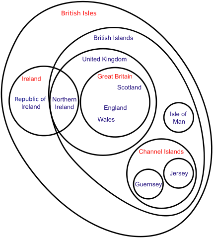
An Euler diagram of British Isles terminology.
Geographic-only locations. Political entities (may also be geographic terms).
Licensing
 |
I, the copyright holder of this work, hereby grant the permission to copy, distribute and/or modify this document under the terms of the GNU Free Documentation License, Version 1.2 or any later version published by the Free Software Foundation; with no Invariant Sections, no Front-Cover Texts, and no Back-Cover Texts. |
File history
Click on a date/time to view the file as it appeared at that time.
| Date/Time | Dimensions | User | Comment | |
|---|---|---|---|---|
| current | 10:23, 1 January 2008 | 802×896 (116 KB) | Ipankonin ( Talk | contribs) | ("British Islands") |
| revert | 10:07, 1 January 2008 | 802×896 (126 KB) | Ipankonin ( Talk | contribs) | (smoother outer circle) |
| revert | 09:37, 1 January 2008 | 808×861 (126 KB) | Ipankonin ( Talk | contribs) | (New political entity - "British Crown") |
| revert | 16:15, 26 August 2007 | 794×741 (71 KB) | Crazyjimbo ( Talk | contribs) | |
| revert | 08:24, 2 July 2007 | 794×741 (71 KB) | Naomhain ( Talk | contribs) | (Reverted to earlier revision) |
| revert | 08:23, 2 July 2007 | 794×741 (71 KB) | Naomhain ( Talk | contribs) | (Reverted to earlier revision) |
| revert | 11:23, 25 May 2007 | 794×741 (72 KB) | Grahamzilch ( Talk | contribs) | (Reverted to earlier revision) |
| revert | 21:19, 17 May 2007 | 794×741 (71 KB) | BarryNorton ( Talk | contribs) | (Changed political Ireland to Republic of Ireland) |
| revert | 21:12, 17 May 2007 | 794×741 (71 KB) | BarryNorton ( Talk | contribs) | (Small update to existing file, no change in license) |
| revert | 19:15, 25 April 2007 | 794×741 (72 KB) | Grahamzilch ( Talk | contribs) | (fix typo) |
| revert | 12:03, 17 April 2007 | 794×741 (72 KB) | Grahamzilch ( Talk | contribs) | (another attempt) |
| revert | 10:43, 17 April 2007 | 787×767 (131 KB) | Grahamzilch ( Talk | contribs) | (Reverted to earlier revision) |
| revert | 10:43, 17 April 2007 | 392×366 (72 KB) | Grahamzilch ( Talk | contribs) | (uploaded wrong copy) |
| revert | 10:41, 17 April 2007 | 794×741 (72 KB) | Grahamzilch ( Talk | contribs) | (Reverted to earlier revision) |
| revert | 10:38, 17 April 2007 | 787×767 (131 KB) | Grahamzilch ( Talk | contribs) | (SVG trouble - tweaking) |
| revert | 10:18, 17 April 2007 | 794×741 (72 KB) | Grahamzilch ( Talk | contribs) | (Channel Islands are included in British Isles - see OED, Encarta, Idiots Guide to Geography, Languages in the British Isles, Guernsey and Jersey govt. websites, etc. etc. etc. Only WP excludes them.) |
| revert | 13:15, 26 March 2007 | 787×767 (131 KB) | Jeanne dArc ( Talk | contribs) | (Reverted to earlier revision) |
| revert | 13:15, 26 March 2007 | 698×694 (133 KB) | Jeanne dArc ( Talk | contribs) | (Reverted to earlier revision) |
| revert | 20:50, 20 March 2007 | 698×694 (132 KB) | Lexicon ( Talk | contribs) | (Minor tweaks.) |
| revert | 20:38, 20 March 2007 | 698×694 (133 KB) | Lexicon ( Talk | contribs) | (Slightly less whitespace.) |
| revert | 20:32, 20 March 2007 | 787×767 (131 KB) | Lexicon ( Talk | contribs) | (Euler diagram of British Isles terminology.) |
See the setup instructions for more information.
File links
The following pages on Schools Wikipedia link to this image (list may be incomplete):
Categories: Self-published work | GFDL images