Image:British Isles Rockall.svg

From Wikipedia, the free encyclopedia
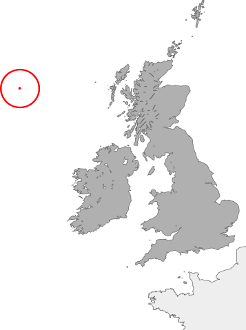
British_Isles_Rockall.svg‎ (SVG file, nominally 880 × 1,180 pixels, file size: 138 KB)

Wikimedia Commons logo This is a file from the Wikimedia Commons. The description on its description page there is shown below.
Commons is a freely licensed media file repository. You can help.

Summary

Summary

Description

map showing the location of Rockall in relation to Great Britain and Ireland

Source

self-made

Date

2007-21-09

Author

Cnbrb

Permission
( Reusing this image)

see below


Licensing

Public domain
I, the copyright holder of this work, hereby release it into the public domain. This applies worldwide.

In case this is not legally possible:
I grant anyone the right to use this work for any purpose, without any conditions, unless such conditions are required by law.


Afrikaans | Alemannisch | Aragonés | العربية | Asturianu | Български | Català | Cebuano | Česky | Cymraeg | Dansk | Deutsch | Eʋegbe | Ελληνικά | English | Español | Esperanto | Euskara | Estremeñu | فارسی | Français | Galego | 한국어 | हिन्दी | Hrvatski | Ido | Bahasa Indonesia | Íslenska | Italiano | עברית | Kurdî / كوردی | Latina | Lietuvių | Latviešu | Magyar | Македонски | Bahasa Melayu | Nederlands | ‪Norsk (bokmål)‬ | ‪Norsk (nynorsk)‬ | 日本語 | Polski | Português | Ripoarisch | Română | Русский | Shqip | Slovenčina | Slovenščina | Српски / Srpski | Suomi | Svenska | ไทย | Tagalog | Türkçe | Українська | Tiếng Việt | Walon | ‪中文(简体)‬ | ‪中文(繁體)‬ | zh-yue-hant | +/-

File history

Click on a date/time to view the file as it appeared at that time.

Date/Time Dimensions User Comment
current 02:06, 21 October 2007 880×1,180 (138 KB) Cnbrb (== Summary == {{Information |Description=map showing the location of Rockall in relation to Great Britain and Ireland |Source=self-made |Date=2007-21-09 |Author= Cnbrb }} Category:Locator maps of countries of the United Kingdom [[Categ)
01:55, 21 October 2007 1,175×1,180 (137 KB) Cnbrb (== Summary == {{Information |Description=map showing the location of Rockall in relation to Great Britain and Ireland |Source=self-made |Date=2007-21-09 |Author= Cnbrb }} Category:Locator maps of countries of the United Kingdom [[Categ)
The following pages on Schools Wikipedia link to this image (list may be incomplete):
The 2008 Wikipedia for Schools was sponsored by a UK Children's Charity, SOS Children UK , and consists of a hand selection from the English Wikipedia articles with only minor deletions (see www.wikipedia.org for details of authors and sources). See also our Disclaimer.