Image:USA map 1790.jpg
From Wikipedia, the free encyclopedia

Size of this preview: 534 × 479 pixels
Full resolution (744 × 668 pixels, file size: 572 KB, MIME type: image/jpeg)
Map of the USA in 1790
| |
Permission is granted to copy, distribute and/or modify this document under the terms of the GNU Free Documentation License, Version 1.2 or any later version published by the Free Software Foundation; with no Invariant Sections, no Front-Cover Texts, and no Back-Cover Texts. |
File history
Click on a date/time to view the file as it appeared at that time.
| Date/Time | Thumbnail | Dimensions | User | Comment | |
|---|---|---|---|---|---|
| current | 16:53, 22 November 2007 | 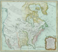 |
744×668 (572 KB) | Budfin ( Talk | contribs) | (Map of the USA in 1790 {{GFDL}}) |
See the setup instructions for more information.
File links
The following pages on Schools Wikipedia link to this image (list may be incomplete):
Metadata
This file contains additional information, probably added from the digital camera or scanner used to create or digitize it. If the file has been modified from its original state, some details may not fully reflect the modified file.
| Orientation | Normal |
|---|---|
| Horizontal resolution | 283460/10000 |
| Vertical resolution | 283460/10000 |
| Software used | Adobe Photoshop CS2 Windows |
| File change date and time | 16:48, 22 November 2007 |
| Colour space | sRGB |
Categories: GFDL images