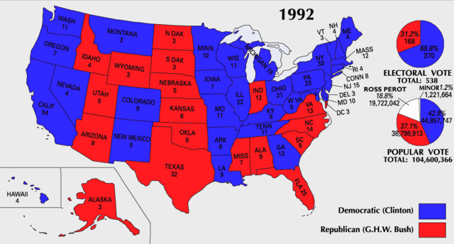
Image:ElectoralCollege1992-Large.png
From Wikipedia, the free encyclopedia

Size of this preview: 640 × 344 pixels
Full resolution (1,182 × 635 pixels, file size: 174 KB, MIME type: image/png)
File history
Click on a date/time to view the file as it appeared at that time.
| Date/Time | Dimensions | User | Comment | |
|---|---|---|---|---|
| current | 10:21, 25 July 2007 | 1,182×635 (174 KB) | Cardsplayer4life | (Reverted to earlier revision) |
| 09:28, 25 July 2007 | 1,182×635 (111 KB) | Joseph Solis in Australia | ({{PD-USGov-Atlas}} Category:1992 {{US presidential election maps}}) | |
| 08:02, 13 July 2007 | 1,182×635 (174 KB) | Cardsplayer4life | ({{PD-USGov-Atlas}} {{ConvertToSVG|map}} {{US presidential election maps}}) | |
| 01:48, 9 July 2007 | 1,182×635 (174 KB) | Cardsplayer4life | ({{PD-USGov-Atlas}} {{ConvertToSVG|map}} {{US presidential election maps}} ) | |
| 09:33, 6 July 2007 | 1,182×635 (111 KB) | Joseph Solis in Australia | ({{PD-USGov-Atlas}} Category:1992 {{US presidential election maps}}) | |
| 02:29, 2 July 2007 | 1,182×635 (174 KB) | Cardsplayer4life | ({{PD-USGov-Atlas}} {{ConvertToSVG|map}} {{US presidential election maps}} ) | |
| 10:10, 29 June 2007 | 1,182×635 (111 KB) | Joseph Solis in Australia | ({{PD-USGov-Atlas}} Category:1992 {{US presidential election maps}}) | |
| 21:01, 21 June 2007 | 1,182×635 (175 KB) | Cardsplayer4life | ({{PD-USGov-Atlas}} {{ConvertToSVG|map}} {{US presidential election maps}} ) | |
| 16:04, 22 January 2006 | 1,182×635 (111 KB) | Red devil 666 | ({{PD-USGov-Atlas}}) |
File links
The following pages on Schools Wikipedia link to this image (list may be incomplete):


