Image:Wfm pelagic.png
From Wikipedia, the free encyclopedia
Size of this preview: 163 × 477 pixels
Full resolution (576 × 1,686 pixels, file size: 179 KB, MIME type: image/png)
| |
This is a file from the Wikimedia Commons. The description on its description page there is shown below. |
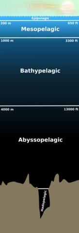
The different parts of the Pelagic zone.
 |
This diagram image should be recreated using vector graphics as an SVG file. This has several advantages; see Commons:Media for cleanup for more information. If an SVG form of this image is already available, please upload it. After uploading an SVG, replace this template with {{ vector version available|new image name.svg}}. |
|
العربية | Български | Català | Česky | Dansk | Deutsch | English | Esperanto | Español | Français | Galego | 한국어 | Italiano | Magyar | Lietuvių | Nederlands | 日本語 | Polski | Português | Română | Русский | Suomi | Svenska | Türkçe | Українська | 中文(繁體) | 中文(简体) | +/- |
|
Version history
- v1. Based on de:Bild:Pelagial Tiefenzonierung.png by de:Benutzer:TomCatX (the "above the waves" image is copied directly from TomCatX's image).
- v2. The first version used a linear gradient, which didn't look correct (the epi was to dark, and the bathy too light). This new version uses a nonlinear gradient (where the brightness falls off logarithmically) which is much closer to reality. I also improved the waves on the ocean surface.
Source document
I'll retain the original Inkscape diagram, so if anyone wants a version in another language I can make the change for you - just ask.
Licence
 |
This image has been released into the public domain by its author, Finlay McWalter. This applies worldwide. In some countries this may not be legally possible; if so: العربية | Български | Deutsch | Ελληνικά | English | Español | Français | Italiano | 日本語 | 한국어 | Polski | Русский | Српски / Srpski | Svenska | தமிழ் | Українська | 中文(繁體) | 中文(简体) +/- |
File history
Click on a date/time to view the file as it appeared at that time.
| Date/Time | Dimensions | User | Comment | |
|---|---|---|---|---|
| current | 18:53, 11 August 2005 | 576×1,686 (179 KB) | Finlay McWalter | (update - nonlinear gradient, improved ocean surface) |
| 17:20, 11 August 2005 | 577×1,686 (133 KB) | Finlay McWalter | (The different parts of the en:Pelagic zone. This is a derivative work of de:Bild:Pelagial Tiefenzonierung.png by de:Benutzer:TomCatX (the "above the waves" image is copied directly from TomCatX's image). {{Bild-PD}}) |