Image:Lake powell utah.jpg
From Wikipedia, the free encyclopedia
Size of this preview: 371 × 480 pixels
Full resolution (773 × 1,000 pixels, file size: 193 KB, MIME type: image/jpeg)
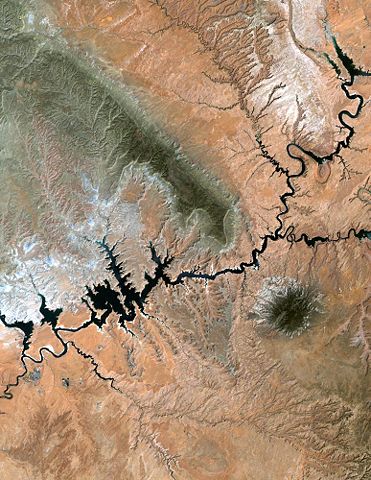
Lake Powell, Utah from NASA's Landsat
Lake Powell in southern Utah stretches hundreds of miles from Lees Ferry in Arizona to the Orange Cliffs of southern Utah. At more than 400 feet deep, 150 miles long, and nearly 2,000 miles of shoreline, Lake Powell is the nation's second largest man-made lake, second only to Lake Mead in Nevada. It is at its lowest water level in over 30 years due to the ongoing drought in the western United States.
source
 |
This file is in the public domain because it was created by NASA. NASA copyright policy states that "NASA material is not protected by copyright unless noted". ( NASA copyright policy page or JPL Image Use Policy)
|
File history
Click on a date/time to view the file as it appeared at that time.
| Date/Time | Dimensions | User | Comment | |
|---|---|---|---|---|
| current | 11:34, 22 March 2005 | 773×1,000 (193 KB) | Darwinek ( Talk | contribs) |
See the setup instructions for more information.
File links
The following pages on Schools Wikipedia link to this image (list may be incomplete):
Categories: NASA images | Images of Utah