Image:Form of government with Freedom House.png
From Wikipedia, the free encyclopedia
Size of this preview: 640 × 296 pixels
Full resolution (1,357 × 628 pixels, file size: 65 KB, MIME type: image/png)
| |
This is a file from the Wikimedia Commons. The description on its description page there is shown below. |
Summary
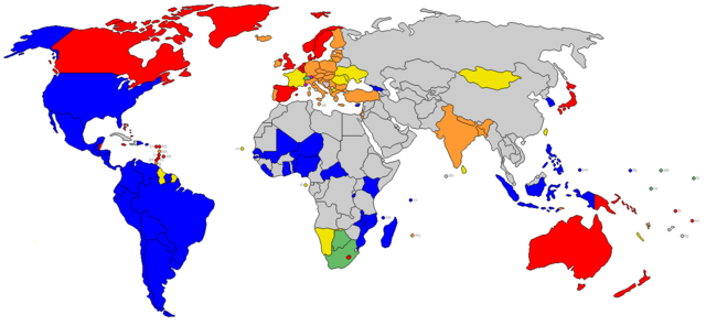
| Description |
World's states coloured by form of government as of 2006, including only electoral democracies as judged by Freedom House
|
|---|---|
| Source |
own work, from existing wikimedia blank world map, melding Image:Form of government.png with data from Image:Freedom House electoral democracies 2006.png |
| Date |
1 May 2006 |
| Author |
The_Tom |
| Permission ( Reusing this image) |
GFDL
|
Licensing
|

 |
This Map image should be recreated using vector graphics as an SVG file. This has several advantages; see Commons:Media for cleanup for more information. If an SVG form of this image is already available, please upload it. After uploading an SVG, replace this template with {{ vector version available|new image name.svg}}. |
|
العربية | Български | Català | Česky | Dansk | Deutsch | English | Esperanto | Español | Français | Galego | 한국어 | Italiano | Magyar | Lietuvių | Nederlands | 日本語 | Polski | Português | Română | Русский | Suomi | Svenska | Türkçe | Українська | 中文(繁體) | 中文(简体) | +/- |
|
File history
Click on a date/time to view the file as it appeared at that time.
| Date/Time | Dimensions | User | Comment | |
|---|---|---|---|---|
| current | 17:24, 29 May 2008 | 1,357×628 (65 KB) | Nightstallion | ({{Information |Description= |Source= |Date= |Author= |Permission= |other_versions= }}) |
| 01:48, 20 April 2008 | 1,357×628 (24 KB) | Supaluminal | (Novaya Zemlya changed from yellow to grey) | |
| 01:46, 16 April 2007 | 1,357×628 (19 KB) | Tene | (Optimised (0)) | |
| 22:46, 11 February 2007 | 1,357×628 (30 KB) | The Tom | (re-added transparency) | |
| 22:20, 11 February 2007 | 1,357×628 (65 KB) | The Tom | (Some unexplainable errors caught (ie, dunno how Libya wound up coloured-in)) | |
| 23:08, 4 January 2007 | 1,357×628 (25 KB) | The Tom | (Miscellaneous updates: Standardized orange, transparency, island state labels) | |
| 15:14, 31 October 2006 | 1,357×628 (35 KB) | Taw | (The orange looked too much like the red, changed to make more distinct.) | |
| 04:34, 22 May 2006 | 1,357×628 (54 KB) | The Tom | (revision to Botswana, Finland, Nepal and Serbia-Montenegro) | |
| 16:42, 9 May 2006 | 1,357×628 (54 KB) | The Tom | (Switzerland edit) | |
| 00:21, 9 May 2006 | 1,357×628 (54 KB) | The Tom | (New base map with black outlines and enlarged microstates. New pale green for South Africa and 3 South Pacific nations. -~~~~) | |
| 00:48, 2 May 2006 | 1,357×628 (54 KB) | The Tom | ({{Information| |Description=World's states coloured by form of government as of 2006, including only electoral democracies as judged by Freedom House |Source=own work, from existing wikimedia blank world map and with data from [[:Image:Freedom House e) |