From Wikipedia, the free encyclopedia
 Size of this preview: 640 × 446 pixels
 Full resolution (1,407 × 981 pixels, file size: 350 KB, MIME type: image/png)
 |
This is a file from the Wikimedia Commons. The description on its description page there is shown below.Commons is a freely licensed media file repository. You can help.
|
| Description |
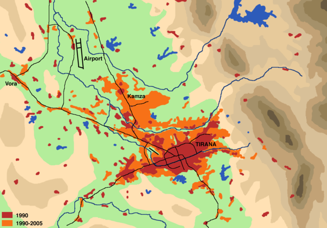
English: Schematical illustration of the population development (settlement area, commercial zones) in the region of Tirana from 1990 to 2005
Deutsch: Schematische Darstellung der Zunahme der Bevölkerungsentwicklung (Siedlungsfläche, Gewerbegebiete) in der Region Tirana zwischen 1990 und 2005
|
| Source |
Drawn by myself on the basis of
- map by Institue for Habitat Development in Besnik Aliaj, Keida Lulo und Genc Myftiu: Tirana - The Challenge of Urban Development (Tirana 2003, ISBN 99927-880-0-3)
- Google Map satellite pictures
- Official Albanian Maps 1:50000 of the late 1980ies
Literature:
Tirana - The Challenge of Urban Development. Tirana 2003, ISBN 99927-880-0-3- Dietmar Richter: Flächennutzungswandel in Tirana. Untersuchungen anhand von Landsat TM, Terra ASTER und GIS. (= Praxis Kultur- und Sozialgeographie; 42). Universitäts-Verlag, Potsdam 2007, ISBN 978-3-939469-64-3 ( complete text)
|
| Date |
May 2007 |
| Author |
User:Albinfo |
Permission
( Reusing this image) |
I, the copyright holder of this work, hereby publish it under the following license:

  |
This file is licensed under the Creative Commons Attribution ShareAlike 2.5 License. In short: you are free to share and make derivative works of the file under the conditions that you appropriately attribute it, and that you distribute it only under a license identical to this one. Official license |
|
|
File history
Click on a date/time to view the file as it appeared at that time.
|
|
Date/Time |
Dimensions |
User |
Comment |
| current |
19:30, 6 May 2007 |
1,407×981 (350 KB) |
Albinfo |
|
File links
The following pages on Schools Wikipedia link to this image (list may be incomplete):
