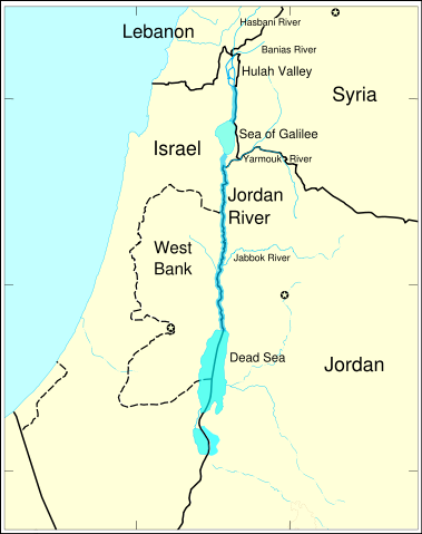
Image:JordanRiver en.svg
From Wikipedia, the free encyclopedia

JordanRiver_en.svg (SVG file, nominally 1,016 × 1,285 pixels, file size: 860 KB)
File history
Click on a date/time to view the file as it appeared at that time.
| Date/Time | Dimensions | User | Comment | |
|---|---|---|---|---|
| current | 16:14, 3 May 2007 | 1,016×1,285 (860 KB) | Interiot | (make the Mediterranean blue) |
| 19:34, 10 April 2007 | 1,016×1,285 (860 KB) | Interiot | (make "Yarmouk River" not intersect with the Syria/Jordan border) | |
| 10:41, 10 April 2007 | 1,016×1,285 (859 KB) | Interiot | (+Yarmouk, +Jabbok) | |
| 10:23, 10 April 2007 | 1,016×1,285 (858 KB) | Interiot | (+tributaries) | |
| 09:19, 10 April 2007 | 1,016×1,285 (855 KB) | Interiot | (tweaks) | |
| 08:07, 10 April 2007 | 1,016×1,285 (1.01 MB) | Interiot | (expand default size; +labels) | |
| 07:53, 10 April 2007 | 388×491 (1.02 MB) | Interiot | (getting closer...) | |
| 20:43, 6 April 2007 | 720×720 (1.77 MB) | Interiot | ('''note: map is still being worked on'''... once complete, English captions will be added here, and a numbered captionless map will be created at Image:JordanRiver_numbered. ---- The Jordan River. Modified from http://www.un.or) |
File links
The following pages on Schools Wikipedia link to this image (list may be incomplete):
Categories: Maps of Jordan | Maps of Israel | Maps of the Palestinian territories | Maps of Syria

