Image:IndoGangeticPlain Map.png
From Wikipedia, the free encyclopedia
No higher resolution available.
IndoGangeticPlain_Map.png (433 × 290 pixels, file size: 27 KB, MIME type: image/png)
| |
This is a file from the Wikimedia Commons. The description on its description page there is shown below. |
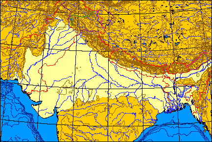
Map of the Indo-Gangetic Plain.
 |
I, the copyright holder of this work, hereby release it into the public domain. This applies worldwide. In case this is not legally possible: Afrikaans | Alemannisch | Aragonés | العربية | Asturianu | Български | Català | Cebuano | Česky | Cymraeg | Dansk | Deutsch | Eʋegbe | Ελληνικά | English | Español | Esperanto | Euskara | Estremeñu | فارسی | Français | Galego | 한국어 | हिन्दी | Hrvatski | Ido | Bahasa Indonesia | Íslenska | Italiano | עברית | Kurdî / كوردی | Latina | Lietuvių | Latviešu | Magyar | Македонски | Bahasa Melayu | Nederlands | Norsk (bokmål) | Norsk (nynorsk) | 日本語 | Polski | Português | Ripoarisch | Română | Русский | Shqip | Slovenčina | Slovenščina | Српски / Srpski | Suomi | Svenska | ไทย | Tagalog | Türkçe | Українська | Tiếng Việt | Walon | 中文(简体) | 中文(繁體) | zh-yue-hant | +/- |
I produced this map myself using the program here and modifying it. It remains in the public domain. The map is an azimuthal equal-area projection. The Line of Control through Kashmir is green. Where the line of control along the Indo-Chinese frontier coincides with one side's territorial claims, the line is pink; borders claimed but not controlled are purple. Non-disputed boudaries are in red. QuartierLatin1968 01:36, 21 May 2005 (UTC)
File history
Click on a date/time to view the file as it appeared at that time.
| Date/Time | Dimensions | User | Comment | |
|---|---|---|---|---|
| current | 01:36, 21 May 2005 | 433×290 (27 KB) | QuartierLatin1968 | (Map of the Indo-Gangetic Plain. {{PD}} I produced this map myself using the program [http://www.aquarius.geomar.de/omc/make_map.html here] and modifying it. It remains in the public domain. The map is an azimuthal equal-area projection. The Line of Contr) |
File links