Image:Kiribati-map-AE.png
From Wikipedia, the free encyclopedia
No higher resolution available.
Kiribati-map-AE.png (300 × 322 pixels, file size: 61 KB, MIME type: image/png)
| |
This is a file from the Wikimedia Commons. The description on its description page there is shown below. |
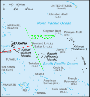
Map of Kiribati from English Wikipedia, where I have added the possible route of Amelia Earhart's last flight.
 |
This image is in the public domain because it contains materials that originally came from the United States Central Intelligence Agency's World Factbook. Deutsch | English | Español | Français | 日本語 | Nederlands | 한국어 | Português | தமிழ் | Magyar | +/- |
 |
File history
Click on a date/time to view the file as it appeared at that time.
| Date/Time | Thumbnail | Dimensions | User | Comment | |
|---|---|---|---|---|---|
| current | 22:27, 25 October 2006 | |
300×322 (61 KB) | Islander | (Map of Kiribati from English Wikipedia, where I have added the possible route of Amelia Earhart's last flight. {{PD-USGov-CIA-WF}}) |
File links
The following pages on Schools Wikipedia link to this image (list may be incomplete):