Image:1947-UN-Partition-Plan-1949-Armistice-Comparison.png
From Wikipedia, the free encyclopedia
Size of this preview: 171 × 479 pixels
Full resolution (367 × 1,029 pixels, file size: 26 KB, MIME type: image/png)
| |
This is a file from the Wikimedia Commons. The description on its description page there is shown below. |
Summary
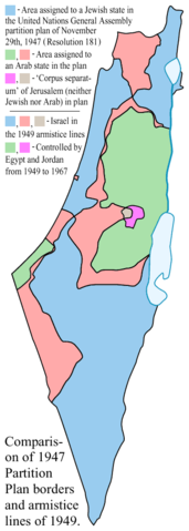
Comparison between the boundaries in the November 29th 1947 United Nations General Assembly partition plan ( Resolution 181) for the British Mandate Territory of Palestine and the eventual armistice boundaries of 1949-1950.
- Blue = area assigned to a Jewish state in the original UN partition plan, and within the 1949 Israel armistice lines.
- Green = area assigned to an Arab state in the original UN partition plan, and controlled by Egypt or Jordan from 1949-1967.
- Light red = area assigned to an Arab state in the original UN partition plan, but within the 1949 Israel armistice lines.
- Magenta = area assigned to the "Corpus Separatum" of Jerusalem/Bethlehem (neither Jewish nor Arab) by the plan, but controlled by Jordan from 1949-1967.
- Greyish = area assigned to the "Corpus Separatum" of Jerusalem/Bethlehem (neither Jewish nor Arab) by the plan, but within the 1949 Israel armistice lines.
Some limitations of the map:
- The small demilitarized zones are not shown. Arabs interpreted these areas as neutral intermediate buffers (like the Neutral Zones between Iraq and Saudi Arabia, or between Kuwait and Saudi Arabia), while Israel interpreted them as full sovereign Israeli national territory under a demilitarization treaty obligation. The conflict between these two interpretations produced frictions which effectively eliminated the special status of most of the zones within a few years.
- A small area at the northeastern corner of the green area on the map -- which would have belonged to the Jewish state according to the original UN partition plan, but which was controlled by Jordan from 1949-1967 -- is not distinguished on the map.
- The map cannot show that the pre-1948 boundaries of the British Palestine Mandate included a ten-meter-wide strip along the northeastern shore of the Sea of Galilee (making it a fully-enclosed British mandate lake), a strip which was overrun by Syria in the fighting of 1948-1949.
Note: A partial SVG conversion (omitting text) of the original PostScript vector source of this image is at Image:1947-UN-Partition-Plan-1949-Armistice-Comparison.svg (which is NOT a vector replacement for this image!).
 |
This map has been uploaded by Electionworld from en.wikipedia.org to enable the |
Licensing
 |
This image has been released into the public domain by its author, AnonMoos. This applies worldwide. In some countries this may not be legally possible; if so: العربية | Български | Deutsch | Ελληνικά | English | Español | Français | Italiano | 日本語 | 한국어 | Polski | Русский | Српски / Srpski | Svenska | தமிழ் | Українська | 中文(繁體) | 中文(简体) +/- |
File history
Click on a date/time to view the file as it appeared at that time.
| Date/Time | Dimensions | User | Comment | |
|---|---|---|---|---|
| current | 16:16, 18 December 2006 | 367×1,029 (26 KB) | Electionworld | ({{ew|en|AnonMoos}} == Summary == Comparison between the boundaries in the November 29th 1947 United Nations General Assembly partition plan ( Resolution 181) for the [[British Mandate of Palestine|British Mandate Territory of Pal) |