Image:Platslc.jpg
From Wikipedia, the free encyclopedia
Size of this preview: 287 × 479 pixels
Full resolution (645 × 1,076 pixels, file size: 718 KB, MIME type: image/jpeg)
 |
This image is in the public domain in the United States. In most cases, this means that it was first published prior to January 1, 1923 (see the template documentation for more cases). Other jurisdictions may have other rules, and this image might not be in the public domain outside the United States. See Wikipedia:Public domain and Wikipedia:Copyrights for more details. |
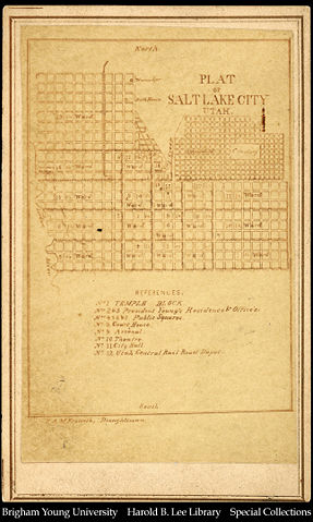
From Library of Congress . Courtesy Special Collections, Harold B. Lee Library, Brigham Young University, Provo, UT 84602.
Photograph of a street map of Salt Lake City called Plat of Salt Lake City, Utah. A street map, showing the blocks and divisions of blocks in the downtown Salt Lake City area produced in the late 1860's by E. Martin, Photographer, East Temple Street, Salt Lake City, Utah Territory.
File history
Click on a date/time to view the file as it appeared at that time.
| Date/Time | Dimensions | User | Comment | |
|---|---|---|---|---|
| current | 01:51, 26 December 2004 | 645×1,076 (718 KB) | JonMoore ( Talk | contribs) | ({{PD-US}} From LOC. Courtesy Special Collections, Harold B. Lee Library, Brigham Young University, Provo, UT 84602. Photograph of a street map of Salt Lake City called Plat of Salt Lake City, Utah. A street map, showing the blocks and divisions of blocks ) |
See the setup instructions for more information.
File links
The following pages on Schools Wikipedia link to this image (list may be incomplete):
Categories: Images in the public domain in the United States | Images of Salt Lake City, Utah