From Wikipedia, the free encyclopedia
 Size of this preview: 402 × 480 pixels
 Full resolution (1,400 × 1,670 pixels, file size: 304 KB, MIME type: image/jpeg)
 |
This is a file from the Wikimedia Commons. The description on its description page there is shown below.Commons is a freely licensed media file repository. You can help.
|
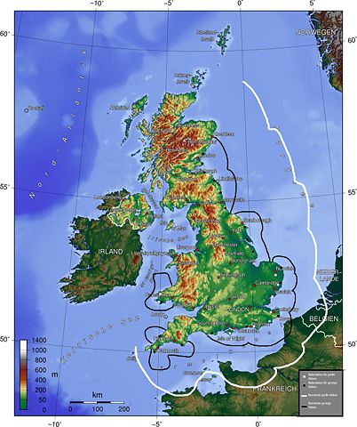
The map (topographic background derived from a German article about Great Britain taken from German wikipedia) gives a quick overview about British radar facilities during the Battle for Britain 1940. I drew the map myself (thats the reason, why it looks quite improvised). Nasiruddin 16:27, 15 August 2005 (UTC)
- Explanation of German legend: White squares indicate high-altitude radar stations, black squares, low-altitude stations. The white line indicates the range of the high-altitude radar, the black line, the range of the low altitude radar.
 |
This image is ineligible for copyright and therefore in the public domain, because it consists entirely of information that is common property and contains no original authorship.
العربية | Afrikaans | Български | Bosanski | Česky | Dansk | Deutsch | English | Esperanto | Español | Français | हिन्दी | Italiano | 日本語 | 한국어 | Magyar | Nederlands | Norsk (nynorsk) | Polski | Português | Русский | Svenska | Türkçe | 中文(繁體) | 中文(简体) | +/- |
File history
Click on a date/time to view the file as it appeared at that time.
|
|
Date/Time |
Dimensions |
User |
Comment |
| current |
16:27, 15 August 2005 |
1,400×1,670 (304 KB) |
Nasiruddin |
|
File links
The following pages on Schools Wikipedia link to this image (list may be incomplete):

