From Wikipedia, the free encyclopedia
 Size of this preview: 240 × 480 pixels
 Full resolution (1,800 × 3,600 pixels, file size: 3.89 MB, MIME type: image/png)
 |
This is a file from the Wikimedia Commons. The description on its description page there is shown below.Commons is a freely licensed media file repository. You can help.
|
Sumario
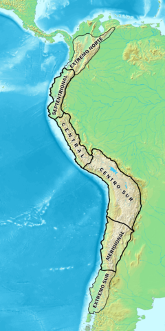
Español: Mapa donde se indica las áreasen que se divide el área cultural Andina.
English: Map showing the areas in which the Andean cultural area is divided.
Origen (Source)>/sub>
English: Made and uploaded by Huhsunqu, based on Category:Topographic maps.
Español: Hecho y subido por Huhsunqu, basado en Category:Topographic maps.
Français : Réalisé et mis en ligne par Huhsunqu, à partir de Category:Topographic maps.
Italiano: File fatto e caricato da Huhsunqu, basato in Category:Topographic maps.
Português: Feito e carregato por Huhsunqu.
Runa Simi: Kaytaqa Huhsunqupam tiksisqan yapasqanpas , Category:Topographic maps nisqamanta rurasqa.
Runa Simi: Kaytaqa Huhsunqupam tiksishqan yapashqanpis , Category:Topographic maps nishqapita rurashqa.
Licensing
I, the copyright holder of this work, hereby publish it under the following license:

  |
This file is licensed under the Creative Commons Attribution ShareAlike 2.5 License. In short: you are free to share and make derivative works of the file under the conditions that you appropriately attribute it, and that you distribute it only under a license identical to this one. Official license |
|
File history
Click on a date/time to view the file as it appeared at that time.
|
|
Date/Time |
Dimensions |
User |
Comment |
| current |
08:59, 5 January 2007 |
1,800×3,600 (3.89 MB) |
Huhsunqu |
|
File links
The following pages on Schools Wikipedia link to this image (list may be incomplete):
