From Wikipedia, the free encyclopedia
 Size of this preview: 333 × 479 pixels
 Full resolution (2,400 × 3,450 pixels, file size: 2.09 MB, MIME type: image/jpeg)
 |
This is a file from the Wikimedia Commons. The description on its description page there is shown below.Commons is a freely licensed media file repository. You can help.
|
Summary
| Camera location Scotland map-en.jpg |
57°00′00″N, 04°00′00″W 57;-4 |
This and other geocoded Commons images:
|
( Info) |
| Description |
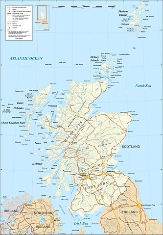
Map in English of Scotland
This is a lighter raster JPG format version of Image:Scotland_map-en.svg which should be used in the article pages, the vector graphics version purpose being for modification and / or translation ;
Approximate scales of shaded relief and shore / lakes limits : 1:3,000,000 (accuracy : about 750 m) until 60.38° and 1:4,000,000 (accuracy : about 1,000 m) North of 60.38° |
| Source |
Own work (see complete description on Image:Scotland_map-en.svg) |
| Date |
December 2007 |
| Author |
Eric Gaba ( Sting) |
Permission
( Reusing this image) |
Attribution and Share-Alike required |
| Other versions |
Topographic, SVG - English
|
Topographic, raster - English
|
Topographique SVG - Français
|
Topographique bitmap - Français
|
Topografisch, SVG - Deutsch
|
Topografisk, SVG – norsk (bokmål)
|
Topografisk, SVG – norsk (nynorsk)
|
Carte topographique simplifiée - Français
|
Vereinfachte topografische Karte - Deutsch
|
SVG version, only with shaded relief - English
|
Raster version, only with shaded relief - English
|
Version SVG, seulement avec relief ombré - Français
|
Version bitmap, seulement avec relief ombré – Français
|
SVG-Version, nur mit schattiertem Relief - Deutsch
|
|
Français :
- Sujet : Carte en anglais de l' Écosse ;
-
-
- Ceci est une version bitmap au format JPG et de poids de fichier plus léger de Image:Scotland_map-en.svg qui devrait être utilisée dans les pages d'articles, la version vectorisée SVG étant destinée à faciliter les modifications et / ou traductions.
- Sources : Création personnelle (voir description complète sur Image:Scotland_map-en.svg) ;
- Échelles approximatives : Relief ombré et tracés des côtes / lacs : 1:3 000 000 (précision : environ 750 m) jusqu'à 60,38° et 1:4 000 000 (précision : environ 1 000 m) au nord de 60,38° ;
- Auteur : Eric Gaba ( fr:Sting) ;
- Date : Décembre 2007.
Licensing
I, the copyright holder of this work, hereby publish it under the following licenses:
 |
Permission is granted to copy, distribute and/or modify this document under the terms of the GNU Free Documentation license, Version 1.2 or any later version published by the Free Software Foundation; with no Invariant Sections, no Front-Cover Texts, and no Back-Cover Texts. A copy of the license is included in the section entitled " GNU Free Documentation license".
Aragonés | العربية | Asturianu | Беларуская (тарашкевіца) | Български | বাংলা | ইমার ঠার/বিষ্ণুপ্রিয়া মণিপুরী | Brezhoneg | Bosanski | Català | Cebuano | Česky | Dansk | Deutsch | Ελληνικά | English | Esperanto | Español | Eesti | Euskara | فارسی | Suomi | Français | Gaeilge | Galego | עברית | Hrvatski | Magyar | Bahasa Indonesia | Ido | Íslenska | Italiano | 日本語 | ქართული | ភាសាខ្មែរ | 한국어 | Kurdî / كوردی | Latina | Lëtzebuergesch | Lietuvių | Bahasa Melayu | Nnapulitano | Nederlands | Norsk (nynorsk) | Norsk (bokmål) | Occitan | Polski | Português | Română | Русский | Slovenčina | Slovenščina | Shqip | Српски / Srpski | Svenska | తెలుగు | ไทย | Tagalog | Türkçe | Українська | اردو | Tiếng Việt | Volapük | Yorùbá | 中文(简体) | 中文(繁體) | +/- |
You may select the license of your choice.
|
File history
Click on a date/time to view the file as it appeared at that time.
|
|
Date/Time |
Dimensions |
User |
Comment |
| current |
22:28, 17 June 2008 |
2,400×3,450 (2.09 MB) |
Sting |
|
|
|
01:24, 14 December 2007 |
2,400×3,450 (2.22 MB) |
Sting |
|
|
|
19:53, 13 December 2007 |
2,400×3,450 (2.22 MB) |
Sting |
|
File links
The following pages on Schools Wikipedia link to this image (list may be incomplete):


