Image:Wayne County Michigan Incorporated and Unincorporated areas Detroit highlighted.svg

From Wikipedia, the free encyclopedia

Wayne_County_Michigan_Incorporated_and_Unincorporated_areas_Detroit_highlighted.svg‎ (SVG file, nominally 1,200 × 800 pixels, file size: 136 KB)

Wikimedia Commons logo This is a file from the Wikimedia Commons. The description on its description page there is shown below.
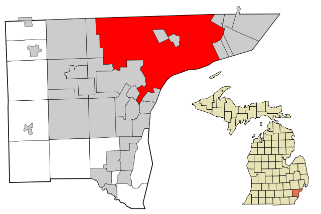
Commons is a freely licensed media file repository. You can help.
Description

This map shows the incorporated and unincorporated areas in Wayne County, Michigan, highlighting Detroit in red. I created it in Inkscape using data from the US Census Bureau.

Source

My own work, based on public domain information. Based on similar map concepts by Ixnayonthetimmay

Date

23 April 2007

Author

Arkyan

Permission
( Reusing this image)

Own work, copyleft: Multi-license with GFDL and Creative Commons CC-BY-SA-2.5 and older versions (2.0 and 1.0)


I, the copyright holder of this work, hereby publish it under the following licenses:
GNU head Permission is granted to copy, distribute and/or modify this document under the terms of the GNU Free Documentation license, Version 1.2 or any later version published by the Free Software Foundation; with no Invariant Sections, no Front-Cover Texts, and no Back-Cover Texts. A copy of the license is included in the section entitled " GNU Free Documentation license".

Aragonés | العربية | Asturianu | Беларуская (тарашкевіца) | Български | বাংলা | ইমার ঠার/বিষ্ণুপ্রিয়া মণিপুরী | Brezhoneg | Bosanski | Català | Cebuano | Česky | Dansk | Deutsch | Ελληνικά | English | Esperanto | Español | Eesti | Euskara | فارسی | Suomi | Français | Gaeilge | Galego | עברית | Hrvatski | Magyar | Bahasa Indonesia | Ido | Íslenska | Italiano | 日本語 | ქართული | ភាសាខ្មែរ | 한국어 | Kurdî / كوردی | Latina | Lëtzebuergesch | Lietuvių | Bahasa Melayu | Nnapulitano | Nederlands | ‪Norsk (nynorsk)‬ | ‪Norsk (bokmål)‬ | Occitan | Polski | Português | Română | Русский | Slovenčina | Slovenščina | Shqip | Српски / Srpski | Svenska | తెలుగు | ไทย | Tagalog | Türkçe | Українська | اردو | Tiếng Việt | Volapük | Yorùbá | ‪中文(简体)‬ | ‪中文(繁體)‬ | +/-

Some rights reserved
Creative Commons Attribution icon Creative Commons Share Alike icon
This file is licensed under the Creative Commons Attribution ShareAlike license versions 2.5, 2.0, and 1.0

العربية | Български | Català | Česky | Dansk | Deutsch | English | Español | Euskara | فارسی | Français | Galego | עברית | Italiano | 日本語 | 한국어 | Lietuvių | Nederlands | Polski | Português | Русский | Svenska | தமிழ் | తెలుగు | Türkçe | 中文 | 中文 | +/-

You may select the license of your choice.

File history

Click on a date/time to view the file as it appeared at that time.

Date/Time Dimensions User Comment
current 19:30, 23 April 2007 1,200×800 (136 KB) Shereth ({{Information |Description=This map shows the incorporated and unincorporated areas in Wayne County, Michigan, highlighting Detroit in red. I created it in Inksc)
The following pages on Schools Wikipedia link to this image (list may be incomplete):
The 2008 Wikipedia for Schools has a sponsor: SOS Children , and is a hand-chosen selection of article versions from the English Wikipedia edited only by deletion (see www.wikipedia.org for details of authors and sources). See also our Disclaimer.