Image:Lewis and Clark Columbia River.jpg
From Wikipedia, the free encyclopedia
Size of this preview: 521 × 479 pixels
Full resolution (1,584 × 1,457 pixels, file size: 1.18 MB, MIME type: image/jpeg)
| |
This is a file from the Wikimedia Commons. The description on its description page there is shown below. |
| Description |
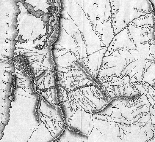
Detail of the Lewis & Clark expedition map showing the Columbia River. The Willamette River is identified as the "Multnomah River." The Snake River is "Lewis's River." |
|---|---|
| Source |
|
| Date |
2008-05-31 21:47 (UTC) |
| Author |
|
| Permission ( Reusing this image) |
see below
|
 |
This image (or other media file) is in the public domain because its copyright has expired. This applies to the United States, Canada, the European Union and those countries with a copyright term of life of the author plus 70 years. العربية | Asturianu | Български | Català | Česky | Dansk | Deutsch | English | Ελληνικά | Esperanto | Español | Euskara | فارسی | Français | Gaeilge | Galego | עברית | हिन्दी | Bahasa Indonesia | Italiano | 日本語 | 한국어 | Kurdî / كوردی | Lietuvių | Magyar | Nederlands | Norsk (nynorsk) | Македонски | Bahasa Melayu | Polski | Português | Română | Русский | Slovenčina | Slovenščina | Shqip | Suomi | Sámegiella | Türkçe | 中文(简体) | 中文(繁體) | 粵語 | +/- |
Original upload log
This image is a derivative work of the following images:
- 2006-01-06T20:10:08Z Brian0918 7000x3043 (10674416 Bytes) Author: Lewis, Meriwether ; Clark, William ; Biddle, Nicholas ; Allen, Paul Date: 1814 Short Title: Map of Lewis and Clark's Track, Across the Western Portion of North America. Publisher: Philadelphia: Bradford and Insk
Uploaded with derivativeFX
File history
Click on a date/time to view the file as it appeared at that time.
| Date/Time | Dimensions | User | Comment | |
|---|---|---|---|---|
| current | 21:48, 31 May 2008 | 1,584×1,457 (1.18 MB) | Northwest-historian | ({{Information |Description=Detail of the Lewis & Clark expedition map showing the Columbia River. The Willamette River is identified as the "Multnomah River." The Snake River is "Lewis's River." |Source=*[[:Image:Map_of_Lewis_and_Clark's_Track,_Across_the) |
File links
Metadata
This file contains additional information, probably added from the digital camera or scanner used to create or digitize it. If the file has been modified from its original state, some details may not fully reflect the modified file.
| Orientation | Normal |
|---|---|
| Horizontal resolution | 72 dpi |
| Vertical resolution | 72 dpi |
| Software used | Adobe Photoshop CS2 Windows |
| File change date and time | 14:41, 31 May 2008 |
| Colour space | 65535 |