From Wikipedia, the free encyclopedia
 Size of this preview: 640 × 282 pixels
 Full resolution (1,427 × 628 pixels, file size: 55 KB, MIME type: image/png)
 |
This is a file from the Wikimedia Commons. The description on its description page there is shown below.Commons is a freely licensed media file repository. You can help.
|
|
A vector version of this image (SVG) is available.
It should be used in place of this raster image when superior.
Image:WOT map4a.PNG  Image:War on terror attack map.svg Image:War on terror attack map.svg
For more information about vector graphics, read about Commons transition to SVG.
There is also information about MediaWiki's support of SVG images.
Deutsch | English | Español | Français | Galego | עברית | Magyar | Italiano | 日本語 | 한국어 | Lietuvių | Polski | Português | Русский | Српски / Srpski | Українська | +/- |
 |
| Description |
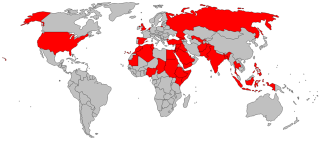
Countries in which Islamist terrorist attacks have occured on or after September 11, 2001. |
| Source |
Originally from en.wikipedia; description page is/was here. |
| Date |
2007-01-18 (original upload date) |
| Author |
Original uploader was Getoar at en.wikipedia |
Permission
( Reusing this image) |
Released into the public domain (by the author).
|
License information
 |
This image has been (or is hereby) released into the public domain by its author, Getoar at the wikipedia project. This applies worldwide.
In case this is not legally possible:
Getoar grants anyone the right to use this work for any purpose, without any conditions, unless such conditions are required by law. |
Original upload log
(All user names refer to en.wikipedia)
- 2007-01-18 03:57 Getoar 1427×628×8 (56387 bytes)
Source
Source needed.
File history
Click on a date/time to view the file as it appeared at that time.
|
|
Date/Time |
Dimensions |
User |
Comment |
| current |
09:57, 23 March 2007 |
1,427×628 (55 KB) |
Liftarn |
|
File links
The following pages on Schools Wikipedia link to this image (list may be incomplete):


