Image:Song Dynasty Map.JPG
From Wikipedia, the free encyclopedia
Size of this preview: 474 × 479 pixels
Full resolution (834 × 843 pixels, file size: 89 KB, MIME type: image/jpeg)
| |
This is a file from the Wikimedia Commons. The description on its description page there is shown below. |
| Description |
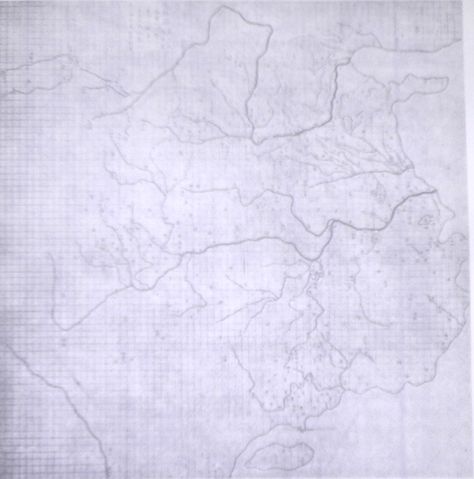
The Chinese Yu Ji Tu (Map of the Tracks of Yu the Great), a map carved into stone in the year 1137 during the Song Dynasty, located in the Stele Forest of modern-day Xian, China. Yu the Great refers to the Chinese deity described in the 5th century Chinese geographical work of the Yu Gong, a chapter of the Classic of History. Needham and Chavannes assert that the original map must have predated the 12th century. The graduated scale of this gridded map is at 100 li (Chinese mile) squared for every representative square in the grid. The overall size of the map is 3 ft squared. The coastal outline is relatively firm and the precision of the network of river systems is incredibly accurate. The name of the geographers and cartographers who initially created the map are unknown. In the year 1142 a copy of the map was preserved at Zhenjiang in Jiangsu province by a certain Yu Chi, who was then a Prefectural Director of Studies. There is also mention of an earlier copy of about 1100 AD which itself was based on the Chang'an version. Needham asserts that the map was used primarily to instruct students while referring to sites described in the ancient Yu Gong chapter of the Classic of History. This image is taken from Joseph Needham's Science and Civilization in China: Volume 3, Mathematics and the Sciences of the Heavens and the Earth, on the page PLATE LXXXI, as well as described on pages 547 to 549 (hardback copy). I, PericlesofAthens, took the photo of this public domain image. |
|---|---|
| Source |
My book, the 3rd Volume by Needham |
| Date |
November 3, 2007 |
| Author |
PericlesofAthens |
| Permission ( Reusing this image) |
see below
|
 |
This image (or other media file) is in the public domain because its copyright has expired. This applies to the United States, Canada, the European Union and those countries with a copyright term of life of the author plus 70 years. العربية | Asturianu | Български | Català | Česky | Dansk | Deutsch | English | Ελληνικά | Esperanto | Español | Euskara | فارسی | Français | Gaeilge | Galego | עברית | हिन्दी | Bahasa Indonesia | Italiano | 日本語 | 한국어 | Kurdî / كوردی | Lietuvių | Magyar | Nederlands | Norsk (nynorsk) | Македонски | Bahasa Melayu | Polski | Português | Română | Русский | Slovenčina | Slovenščina | Shqip | Suomi | Sámegiella | Türkçe | 中文(简体) | 中文(繁體) | 粵語 | +/- |
File history
Click on a date/time to view the file as it appeared at that time.
| Date/Time | Dimensions | User | Comment | |
|---|---|---|---|---|
| current | 10:32, 3 November 2007 | 834×843 (89 KB) | PericlesofAthens | ({{Information |Description=The Chinese ''Yu Ji Tu'' (Map of the Tracks of Yu the Great), a map carved into stone in the year 1137 during the Song Dynasty, located in the Stele Forest of modern-day Xian, China. Yu the Great refers to the Chinese deity desc) |