Yangtze River
2008/9 Schools Wikipedia Selection. Related subjects: Geography of Asia
| Yangtze River | |
|---|---|
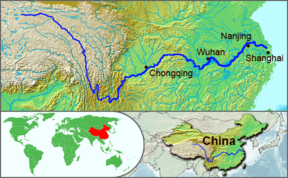
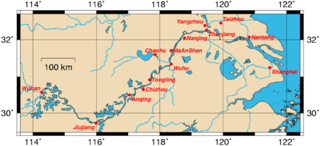
| The course of the Yangtze River through China | |
| Basin countries | China |
| Length | 6,300 km (3,915 mi) |
| Source elevation | 5,042 m (16,542 ft) |
| Avg. discharge | 31,900 m³/s (1,127,000 ft³/s) |
| Basin area | 1,800,000 km² (695,000 mi²) |
The Yangtze River or Chang Jiang ( simplified Chinese: 长 江; traditional Chinese: 長 江; pinyin: Cháng Jiāng) is the longest river in Asia and the third longest in the world, after the Amazon in South America, and the Nile in Africa. The river is about 6,300 km long and flows from its source in Qinghai Province, eastwards into the East China Sea at Shanghai. It has traditionally been considered a dividing line between North and South China, although geographers consider the Qinling- Huai River line to be the official line of geographical division. As the largest river in the region, the Yangtze is historically, culturally, and economically important to China.
| This article contains Chinese text. Without proper rendering support, you may see question marks, boxes, or other symbols instead of Chinese characters. |
The name Yangtze River, as well as various similar names such as Yangtse River, Yangzi River, Yangtze Kiang etc., is derived from Yangzi Jiang ( simplified Chinese: 扬子江; traditional Chinese: 揚子江; pinyin: Yángzǐ Jiāng) listen , which, beginning in the Sui Dynasty, was the Chinese name for the river in its lower reaches, specifically, the stretch between Yangzhou (扬州) and Zhenjiang (镇江). The name derives from the ancient ferry crossing Yangzi Jin (扬子津, meaning "Yangzi Crossing"). From the Ming dynasty, the name was sometimes written 洋子 (yángzĭ). Because it was the name first heard by missionaries and traders, this name was applied in English to the entire river. In Chinese, Yangzi Jiang is considered a historical or poetic name for the river. The modern Chinese name, Chang Jiang (长江/長江 Cháng Jiāng), literally means "long river" and may sometimes also be used in English.
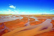
Like many rivers, the river is known by different names over its course. At its source it is called in Chinese the Dangqu (当曲, from the Tibetan for "marsh river"). Downstream it is called the Tuotuo River (沱沱河) and then the Tongtian River (通天河, literally "pass to heaven river"). Where it runs through deep gorges parallel to the Mekong and the Salween before emerging onto the plains of Sichuan, it is known as the Jinsha River (金沙江 Jīnshā Jiāng, literally "golden sands river").
The Yangtze was earlier known to the Chinese as simply Jiang (江 Jiāng), which has become a generic name meaning "river," or the Da Jiang (大江 Dà Jiāng, literally "great river"). The Tibetan name for the river is Drichu ( Tibetan: འབྲི་ཆུ་; Wylie: 'bri chu, lit. "river of the female yak"). The Yangtze is sometimes referred to as the Golden Waterway.
Geography
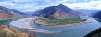
The river originates in a glacier lying on the west of Geladandong mountain in the Dangla Mountain Range on the eastern part of the Tibetan plateau. It runs through the eastern part of Qinghai, turning southward down a deep valley at the border of Sichuan and Tibet to reach Yunnan. In the course of this valley, the river's elevation drops from above 5000 m to less than 1000 m.
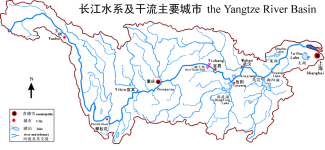
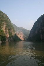
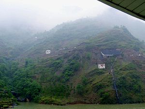
It enters the basin of Sichuan at Yibin. While in the Sichuan basin it receives several mighty tributaries, increasing its water volume significantly. It then cuts through Mount Wushan bordering Chongqing and Hubei to create the famous Three Gorges. Eastward of the Three Gorges, Yichang is the first city on the Yangtze Plain.
After entering Hubei, the Yangtze receives more water from thousands of lakes. The largest of these lakes is Dongting Lake, which is located on the border of Hunan and Hubei provinces, and is the outlet for most of the rivers in Hunan. At Wuhan it receives its biggest tributary, the Han River, bringing water from its northern basin as far as Shaanxi.
At the northern tip of Jiangxi, Lake Poyang, the biggest lake in China, merges into the river. The river then runs through Anhui and Jiangsu provinces, receiving more water from innumerable smaller lakes and rivers, and finally reaches the East China Sea at Shanghai.
Four of China's five main freshwater lakes contribute their waters to the Yangtze River. Traditionally, the upstream part of the Yangtze River refers to the section from Yibin to Yichang; the middle part refers to the section from Yichang to Hukou, where Boyang Lake meets the river; the downstream part is from Hukou to Shanghai.
Environment
In 2007 fears were expressed that China's Finless Porpoise, known locally as the jiangzhu or "river pig", might follow the baiji, the Yangtze river dolphin, into extinction. The baiji was declared functionally extinct in 2006.
Calls have been made for action to be taken to save the porpoise, of which there are about 1400 left living, with between 700 and 900 in the Yangtze, with about another 500 in Poyang and Dongting Lakes.
2007 population levels are less than half the 1997 levels, and the population is dropping at a rate of 7.3 percent per year.
Heavy river traffic on the Yangtze has driven the porpoise into the lakes. On Poyang Lake, the largest freshwater lake in China, sand dredging has become a mainstay of local economical development in the last few years, and is an important source of revenue in the region that border it. But at the same time, high-density dredging projects have been the principal cause of the death of the local wildlife population.
Dredging makes the waters of the lake muddier, and the porpoises cannot see as far as they once could, and have to rely on their highly-developed sonar systems to avoid obstacles and look for food. Large ships enter and leave the lake at the rate of two a minute and such a high density of shipping means the porpoises have difficulty hearing their food, and also cannot swim freely from one bank to the other. About 30 % of river's major tributaries like Minjiang, Tuojiang, Xiangjiang and Huangpu are heavily polluted by massive quantities of ammonia, nitrogen, phosphorus and other pollutants which are causing significantly smaller fish catch.
The Three Gorges Dam is having a major adverse impact on the Yangtze River basin, especially the biota and archaeology.
Characteristics
The Yangtze flows into the East China Sea and was navigable by ocean-going vessels up to a thousand miles from its mouth even before the Three Gorges Dam was built. As of June 2003, this dam spans the river, flooding Fengjie, the first of a number of towns affected by the massive flood control and power generation project. This is the largest comprehensive irrigation project in the world, and has a significant impact on the China's agriculture. Its proponents argue that it will free people living along the river from floods that have repeatedly threatened them in the past, and will offer them electricity and water transport -- though at the expense of permanently flooding many existing towns (including numerous ancient cultural relics) and causing large-scale changes in the local ecology.
Opponents of the dam point out that there are three different kinds of floods on the Yangtze River: floods which originate in the upper reaches, floods which originate in the lower reaches, and floods along the entire length of the river. They argue that the Three Gorges dam will actually make flooding in the upper reaches worse and have little or no impact on floods which originate in the lower reaches. Twelve hundred years of low water marks on the river were recorded in the inscriptions and the carvings of carp at Baiheliang, now submerged.
The Yangtze is flanked with metallurgical, power, chemical, auto, building materials and machinery industrial belts, and high-tech development zones. It is playing an increasingly crucial role in the river valley's economic growth and has become a vital link for international shipping to the inland provinces. The river is a major transportation artery for China, connecting the interior with the coast. The river used as a waterway for commerce offer now the possibility to cruise at leisure. Since 2004 a European luxury cruising company has brought very high standard and with the help of Swiss hotelier Nicolas C. Solari developed and opened three beautiful vessels now cruising the mighty river. The river is one of the world's busiest waterways. Traffic includes commercial traffic transporting bulk goods such as coal as well as manufactured goods and passengers. Cargo transportation reached 795 million tons in 2005. River cruises several days long especially through the beautiful and scenic Three Gorges area are becoming popular as the tourism industry grows in China.
Flooding along the river has been a major problem. The rainy season in China is May and June in areas south of Yangtze River, and July and August in areas north of it. The huge river system receives water both from southern and northern flanks, which causes its flood season to extend from May to August. Meanwhile, the relatively dense population and rich cities along the river make the floods more deadly and costly. The most recent major floods were the 1998 Yangtze River Floods, but more disastrous were the 1954 Yangtze river floods, killing around 30,000 people. Other severe floods included those of 1911 which killed around 100,000, 1931 (145,000 dead), and 1935 (142,000 dead).
The Yangtze is very polluted, especially in Hubei ( Shashi).
History
The Yangtze Harbour is important to the cultural origins of southern China. Human activity was found in the Three Gorges area as far back as 27 thousand years ago, initiating debate over the origin of the Chinese people. In the Spring and Autumn Period, Ba and Shu were located in the western part of the river, covering modern Sichuan, Chongqing, and western Hubei; Chu was located in the central part of river, corresponding to Hubei, Hunan, Jiangxi, and southern Anhui. Wu and Yue were located in the eastern part of the river, now Jiangsu, Zhejiang, and Shanghai. Although the Yellow River region was richer and more developed at that time, the milder climate and more peaceful environment made the Yangtze river area more suitable for agriculture.
From the Han Dynasty, the region of the Yangtze river became more and more important in China's economy. The establishment of irrigation systems (the most famous one is Dujiangyan, northwest of Chengdu, built during the Warring States period) made agriculture very stable and productive. Early in the Qing dynasty, the region called " Jiangnan" (that includes the southern part of Jiangsu, the northern part of Zhejiang, and the southeastern part of Anhui) provided 1/3-1/2 of the nation's revenues.
Historically, the Yangtze became the political boundary between north China and south China several times (see History of China) because of the difficulty of crossing the river. Many battles took place along the river, the most famous being the Battle of Red Cliffs in 208 AD during the Three Kingdoms period.
Politically, Nanjing was the capital of China several times, although most of the time its territory only covered the southeastern part of China, such as the Wu kingdom in the Three Kingdoms period, the Eastern Jin Dynasty, and smaller countries in the Northern and Southern Dynasties and Five Dynasties and Ten Kingdoms periods. Only the Ming occupied most parts of China from their capital at Nanjing, though it later moved capital to Beijing. The ROC capital was located in Nanjing in the periods 1911-1912, 1927-1937, 1945-1949.
Major cities along the river
- Panzhihua
- Yibin
- Luzhou
- Chongqing
- Yichang
- Jingzhou
- Shashi
- Shishou
- Yueyang
- Xianning
- Wuhan
- Ezhou
- Huangshi
- Huanggang
- Chaohu
- Chizhou
- Jiujiang
- Anqing
- Tongling
- Wuhu
- Hefei
- Chuzhou
- Maanshan
- Taizhou
- Yangzhou
- Zhenjiang
- Nanjing
- Nantong
- Shanghai
- Fengdu
Crossings
Chongqing:
- Caiyuanba Bridge
- Chaotianmen Bridge
- Chongqing Second Bridge Yangtze River Bridge (opened 1995)
- Baidicheng Suspension Bridge (pedestrian bridge)
- Masangxi Bridge
- Shibanpo Bridge (opened 2006)
- Wushan Bridge (opened 2005)
- Fengdu Bridge (opened 1996)
- Maochaojie Bridge
- Wanxian Bridge (opened 1997)
- LumMingYan Bridge (opened 2007)
Hubei:
- Zhicheng Bridge (road/rail bridge, opened 1971)
- Jingzhou Yangtze River Bridge (road bridge, opened 2002)
- Wuhan Yangtze River Bridge (road/rail bridge, opened 1957)
- Second Wuhan Yangtze River Bridge (opened 1995)
- Baishazhou Bridge (opened 2000)
- Yangluo Bridge (road bridge, expected 2007)
- Huangshi Yangtze River Bridge (road bridge, opened 1996)
Jiangxi:
- Jiujiang Yangtze River Bridge (road/rail bridge, opened 1992)
Anhui:
- Anqing Bridge (road bridge, opened 2005)
- Tongling Bridge (road bridge, opened 1995)
- Wuhu Yangtze River Bridge (road/rail bridge, opened 2000)
Jiangsu:
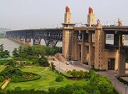
- Nanjing Yangtze River Bridge (road/rail bridge, opened 1968)
- Runyang Bridge (road bridge, opened 2005)
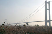
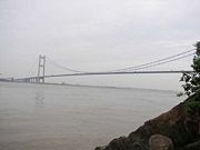
- Jiangyin Suspension Bridge (road bridge, opened 1999)
- Sutong Bridge (road bridge, expected 2008)
Jiangsu and Shanghai:
- Chongqi Bridge(road bridge, expected 2010)
- Shanghai Yangtze River Bridge(road & metro bridge, expected 2010)
- Shanghai Yangtze River Tunnel(road & metro tunnel, expected 2010)
Dams
By 2007, there are two dams on the Yangtze river: Three Gorges Dam and Gezhouba Dam. The third one Xiluodu Dam is under construction. More dams are in planning stage, such as Wudongde, Baihetan, and Xiangjiaba.
Tributaries
The Yangtze River has over 700 tributaries but the principal tributaries are the following:
- Yalong River
- Minjiang River
- Jialing River
- Tuo he(river)
- Han River
