Image:Pearlmap2.png

From Wikipedia, the free encyclopedia

Wikimedia Commons logo This is a file from the Wikimedia Commons. The description on its description page there is shown below.
Commons is a freely licensed media file repository. You can help.

Summary

Description

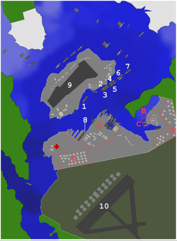
Map of ships and port facilities in Pearl Harbour during the attack.

1: USS California
2: USS Maryland
3: USS Oklahoma
4: USS Tennessee
5: USS West Virginia
6: USS Arizona
7: USS Nevada
8: USS Pennsylvania
9: Ford Island NAS
10: Hickam field

A:Oil storage tanks
B:CINCPAC
C:Submarine base
D:Naval yard

Source

self-made using map from http://www.navsource.org/Naval/ as a reference.

Date

03:37, 26 October 2007 (UTC)

Author

Anynobody

Permission
( Reusing this image)

see below


Licensing

I, the copyright holder of this work, hereby publish it under the following licenses:
GNU head Permission is granted to copy, distribute and/or modify this document under the terms of the GNU Free Documentation license, Version 1.2 or any later version published by the Free Software Foundation; with no Invariant Sections, no Front-Cover Texts, and no Back-Cover Texts. A copy of the license is included in the section entitled " GNU Free Documentation license".

Aragonés | العربية | Asturianu | Беларуская (тарашкевіца) | Български | বাংলা | ইমার ঠার/বিষ্ণুপ্রিয়া মণিপুরী | Brezhoneg | Bosanski | Català | Cebuano | Česky | Dansk | Deutsch | Ελληνικά | English | Esperanto | Español | Eesti | Euskara | فارسی | Suomi | Français | Gaeilge | Galego | עברית | Hrvatski | Magyar | Bahasa Indonesia | Ido | Íslenska | Italiano | 日本語 | ქართული | ភាសាខ្មែរ | 한국어 | Kurdî / كوردی | Latina | Lëtzebuergesch | Lietuvių | Bahasa Melayu | Nnapulitano | Nederlands | ‪Norsk (nynorsk)‬ | ‪Norsk (bokmål)‬ | Occitan | Polski | Português | Română | Русский | Slovenčina | Slovenščina | Shqip | Српски / Srpski | Svenska | తెలుగు | ไทย | Tagalog | Türkçe | Українська | اردو | Tiếng Việt | Volapük | Yorùbá | ‪中文(简体)‬ | ‪中文(繁體)‬ | +/-

Some rights reserved
Creative Commons Attribution icon Creative Commons Share Alike icon
This file is licensed under the Creative Commons Attribution ShareAlike license versions 3.0, 2.5, 2.0, and 1.0

Български | Català | Česky | Dansk | Deutsch | Ελληνικά | English | Español | Euskara | Estremeñu | Français | עברית | Italiano | 日本語 | 한국어 | Lietuvių | Nederlands | ‪Norsk (bokmål)‬  | Occitan | Polski | Piemontèis | Português | Русский | 中文 | +/-

You may select the license of your choice.

File history

Click on a date/time to view the file as it appeared at that time.

Date/Time Dimensions User Comment
current 02:39, 16 November 2007 1,292×1,760 (468 KB) Anynobody
23:55, 7 November 2007 1,292×1,760 (629 KB) Anynobody
05:32, 26 October 2007 1,292×1,760 (675 KB) Anynobody (w/approx depth, hospital, and seaplane base buildings)
03:39, 26 October 2007 1,290×1,752 (289 KB) Anynobody
03:37, 26 October 2007 1,292×1,760 (289 KB) Anynobody ({{Information |Description=Map of ships and facilities at Pearl Harbour during the attack. |Source=self-made |Date= ~~~~~ |Author= Anynobody }} Category:Anynobody)
The following pages on Schools Wikipedia link to this image (list may be incomplete):
The Schools Wikipedia was sponsored by a UK Children's Charity, SOS Children UK , and is a hand-chosen selection of article versions from the English Wikipedia edited only by deletion (see www.wikipedia.org for details of authors and sources). See also our Disclaimer.