Image:Map of Europe (political).png
From Wikipedia, the free encyclopedia
Size of this preview: 640 × 418 pixels
Full resolution (1,596 × 1,043 pixels, file size: 108 KB, MIME type: image/png)
| |
This is a file from the Wikimedia Commons. The description on its description page there is shown below. |
 |
This map has been uploaded by Electionworld from en.wikipedia.org to enable the |
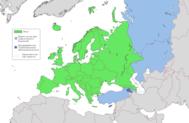
According to one common view of the boundary, the European continent is the area coloured green on this map. The light blue/dark blue colors are described here.
Licensing
|

Map Colors
Geographical Europe is colored green. The Asian territory of states that lie both in Europe and Asia are colored light blue. Dark-blue are colored states that lie entirely on the Asian continent, but are considered European because of religious, cultural and historical reasons. Azerbaijan's exclave of Nakhchivan is also coloured dark-blue because it is not a continuous extension of Azerbaijan's territory.
File history
Click on a date/time to view the file as it appeared at that time.
| Date/Time | Dimensions | User | Comment | |
|---|---|---|---|---|
| current | 13:16, 18 July 2008 | 1,596×1,043 (108 KB) | Aegean Boy | ({{Information |Description= |Source= |Date= |Author= |Permission= |other_versions= }}) |
| 15:03, 20 June 2008 | 1,596×1,043 (107 KB) | Westermarck | ({{Information |Description= |Source= |Date= |Author= |Permission= |other_versions= }}) | |
| 21:02, 15 January 2007 | 1,596×1,043 (108 KB) | Jon Harald Søby | (small change in Azerbaijan's colour) | |
| 14:06, 3 December 2006 | 1,596×1,043 (115 KB) | Electionworld | ({[ew|en|Alinor}} According to one common view of the boundary, the European continent is the area coloured green on this map. The light blue/dark blue colors are described at [[Transcontinental nation#Countries in both Asia and) |
File links
The following file is a duplicate of this file: