Image:New-Orleans-deaths.jpg
From Wikipedia, the free encyclopedia
No higher resolution available.
New-Orleans-deaths.jpg (387 × 354 pixels, file size: 74 KB, MIME type: image/jpeg)
| |
A request has been forwarded to the Graphics Lab for cleanup, improvement, or redrawing. Please discuss this issue on the talk page or at the improvement request page. |
Summary
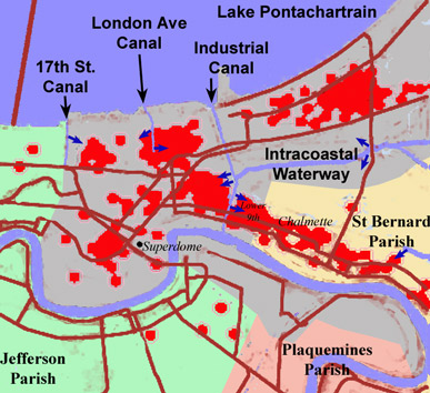
Sketch Map showing Katrina deaths in New Orleans and adjacent parishes (red dots) and principal canal levees/floodwalls which were breached. Red dots for deaths come from The Times Picayune. Dark Blue arrows show levee/flood wall breaches from the above reference and also this one. I used a several references to locate the county boundaries, principal roads and the canals.
Sketch Map drawn by Op.Deo 25 October 2005.
Licensing
 |
I, the copyright holder of this work, hereby release it into the public domain. This applies worldwide. In case this is not legally possible, |
File history
Click on a date/time to view the file as it appeared at that time.
| Date/Time | Dimensions | User | Comment | |
|---|---|---|---|---|
| current | 11:29, 25 October 2005 | 387×354 (74 KB) | Op. Deo ( Talk | contribs) | (== Summary == Sketch Map showing Katrina deaths in New Orleans and adjacent parishes (red dots) and principal canal levees/floodwalls which were breached. Red dots for deaths come from [http://www.nola.com/hurricane/katrina/pdf/102305/1023A01.pdf The Time) |
| revert | 11:22, 25 October 2005 | 387×354 (28 KB) | Op. Deo ( Talk | contribs) | (Sketch Map showing Katrina deaths in New Orleans and adjacent parishes (red dots) and principal canal levees/floodwalls which were breached. Red dots for deaths come from [http://www.nola.com/hurricane/katrina/pdf/102305/1023A01.pdf The Times Picayune]. D) |
See the setup instructions for more information.
File links
The following pages on Schools Wikipedia link to this image (list may be incomplete):
Categories: Images for redraw | User-created public domain images | Images of New Orleans, Louisiana