Image:North Fork Toutle River valley in November 1983.jpg
From Wikipedia, the free encyclopedia
No higher resolution available.
North_Fork_Toutle_River_valley_in_November_1983.jpg (543 × 319 pixels, file size: 32 KB, MIME type: image/jpeg)
| |
This is a file from the Wikimedia Commons. The description on its description page there is shown below. |
Description
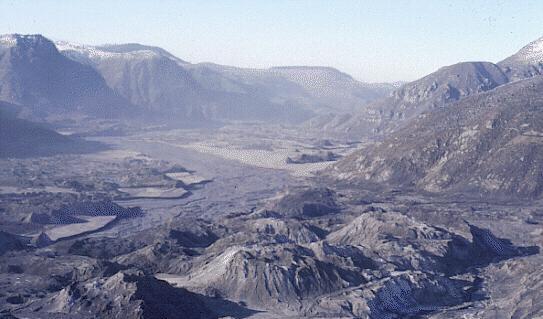
This downstream view of the North Fork Toutle River valley, north and west of St. Helens, shows part of the nearly 2/3 cubic miles (2.3 cubic kilometers) of debris avalanche that slid from the volcano on May 18. This is enough material to cover Washington, D.C. to a depth of 14 feet (4 meters). The avalanche traveled approximately 15 miles (24 kilometers) downstream at a velocity exceeding 150 miles per hour (240 kilometers/hour). It left behind a hummocky deposit with an average thickness of 150 feet (45 meters) and a maximum thickness of 600 feet (180 meters). (November 30, 1983, by Lyn Topinka, USGS/CVO) USGS image
Summary
| Description |
North Fork Toutle River valley in November 1983 |
|---|---|
| Source |
http://vulcan.wr.usgs.gov/Volcanoes/MSH/SlideSet/ljt_slideset_old.html |
| Date | |
| Author |
U.S. government |
| Permission ( Reusing this image) |
PD |
| Other versions | none |
Licensing
 |
This work is in the public domain in the United States because it is a work of the United States Federal Government under the terms of Title 17, Chapter 1, Section 105 of the US Code. See Copyright. Note: This only applies to works of the Federal Government and not to the work of any individual U.S. state, territory, commonwealth, county, municipality, or any other subdivision. This template also does not apply to postage stamps published by the United States Postal Service. (See 206.02(b) of Compendium II: Copyright Office Practices). العربية | Български | Česky | Deutsch | English | Español | Français | Magyar | Italiano | 日本語 | 한국어 | Polski | Português | 中文(繁體) | 中文(简体) | +/- |
 |
 |
Textual information once visible in the image itself has been moved into the image metadata and/or image description page. This makes the image easier to reuse and more language-neutral, and makes the text easier to process and search for. Commons discourages placing visible textual information in images. All licenses accepted on Commons permit this type of modification as a derivative work. If attribution information was removed and the image is not public domain, replace this tag with {{ attribution metadata from licensed image}}. Deutsch | English | Français | Italiano | Português | +/- |
File history
Click on a date/time to view the file as it appeared at that time.
| Date/Time | Dimensions | User | Comment | |
|---|---|---|---|---|
| current | 04:16, 15 July 2008 | 543×319 (32 KB) | Jarekt | ({{Information |Description=Cropped watermark |Source= |Date= |Author= |Permission= |other_versions= }} ) |
| 10:56, 14 March 2006 | 543×353 (39 KB) | Reelax | (== Description == This downstream view of the North Fork Toutle River valley, north and west of St. Helens, shows part of the nearly 2/3 cubic miles (2.3 cubic kilometers) of debris avalanche that slid from the volcano on May 18. This is enough material t) |