Image:Mudline from 1980 St Helens lahars next to Muddy River.jpg
From Wikipedia, the free encyclopedia
No higher resolution available.
Mudline_from_1980_St_Helens_lahars_next_to_Muddy_River.jpg (543 × 319 pixels, file size: 54 KB, MIME type: image/jpeg)
| |
This is a file from the Wikimedia Commons. The description on its description page there is shown below. |
| Description |
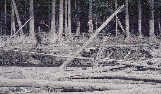
Mount St. Helens Mudline. Nearly 135 miles (220 kilometers) of river channels surrounding the volcano were affected by the lahars of May 18. A mudline left behind on trees shows depths reached by the mud. A scientist (middle right) gives scale. This view is along the Muddy River, southeast of Mount St. Helens. (October 23,1980, by Lyn Topinka, USGS/CVO) |
|---|---|
| Source |
USGS image from |
| Date | |
| Author |
U.S. government |
| Permission ( Reusing this image) |
PD
|
Licensing
 |
This work is in the public domain in the United States because it is a work of the United States Federal Government under the terms of Title 17, Chapter 1, Section 105 of the US Code. See Copyright. Note: This only applies to works of the Federal Government and not to the work of any individual U.S. state, territory, commonwealth, county, municipality, or any other subdivision. This template also does not apply to postage stamps published by the United States Postal Service. (See 206.02(b) of Compendium II: Copyright Office Practices). العربية | Български | Česky | Deutsch | English | Español | Français | Magyar | Italiano | 日本語 | 한국어 | Polski | Português | 中文(繁體) | 中文(简体) | +/- |
 |
 |
Textual information once visible in the image itself has been moved into the image metadata and/or image description page. This makes the image easier to reuse and more language-neutral, and makes the text easier to process and search for. Commons discourages placing visible textual information in images. All licenses accepted on Commons permit this type of modification as a derivative work. If attribution information was removed and the image is not public domain, replace this tag with {{ attribution metadata from licensed image}}. Deutsch | English | Français | Italiano | Português | +/- |
File history
Click on a date/time to view the file as it appeared at that time.
| Date/Time | Dimensions | User | Comment | |
|---|---|---|---|---|
| current | 03:58, 16 July 2008 | 543×319 (54 KB) | Jarekt | ({{Information |Description=Removed watermark |Source= |Date= |Author= |Permission= |other_versions= }} ) |
| 10:32, 11 March 2006 | 543×353 (60 KB) | Reelax | (Nearly 135 miles (220 kilometers) of river channels surrounding the volcano were affected by the lahars of May 18. A mudline left behind on trees shows depths reached by the mud. A scientist (middle right) gives scale. This view is along the Muddy River, ) |