Image:St helens map showing 1980 eruption deposits.png
From Wikipedia, the free encyclopedia
Size of this preview: 639 × 480 pixels
Full resolution (702 × 527 pixels, file size: 18 KB, MIME type: image/png)
Summary
replacing jpeg version, and cropping out extraneous text.
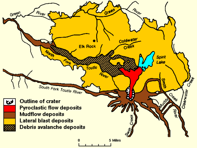
Map of the area around Mount St. Helens which were affected by the May 18, 1980 eruption. North is to the top.
USGS image from
 |
This image is a work of a United States Geological Survey employee, taken or made during the course of the person's official duties. As a work of the United States Government, the image is in the public domain. For more information, see the USGS copyright policy. See Wikipedia:Public domain and Wikipedia:Copyrights for more details. | |
| |
This map image was uploaded in a raster image format such as PNG, GIF, or JPEG. However, it contains information that could be stored more efficiently and/or accurately in the SVG format, as a vector graphic. If possible, please upload an SVG version of this image. After doing so, please replace all instances of the previous version throughout Wikipedia (noted under the “File links” header), tag the old version with {{ Vector version available|NewImage.svg}}, and remove this tag. For more information, see Wikipedia:Preparing images for upload. For assistance with converting to SVG, please see the Graphics Lab. |
 |
Licensing
| |
This work is in the public domain in the United States because it is a work of the United States Federal Government under the terms of Title 17, Chapter 1, Section 105 of the US Code. See Copyright. Note: This only applies to works of the Federal Government and not to the work of any individual U.S. state, territory, commonwealth, county, municipality, or any other subdivision. This template also does not apply to postage stamps published by the United States Postal Service. (See 206.02(b) of Compendium II: Copyright Office Practices). |
 |
File history
Click on a date/time to view the file as it appeared at that time.
| Date/Time | Dimensions | User | Comment | |
|---|---|---|---|---|
| current | 01:18, 27 December 2007 | 702×527 (18 KB) | Peteforsyth ( Talk | contribs) | (replacing jpeg version, and cropping out extraneous text. Map of the area around Mount St. Helens which were affected by the May 18, 1980 eruption. North is to the top. USGS image from [http://vulcan.wr.usgs.gov/Volcanoes/MSH/SlideSet/ljt_slideset_) |
See the setup instructions for more information.
File links
The following pages on Schools Wikipedia link to this image (list may be incomplete):
Categories: USGS images | Map images that should be in SVG format | United States government images