Image:Threegorges.png
From Wikipedia, the free encyclopedia
Size of this preview: 640 × 241 pixels
Full resolution (690 × 260 pixels, file size: 82 KB, MIME type: image/png)
| |
This is a file from the Wikimedia Commons. The description on its description page there is shown below. |
| Description |
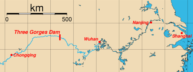
Map of the location of the Three Gorges Dam, Sandouping, Yichang, w:en:HubeiHubei Province, China and major cities along the Yangtze River. This map was generated using the Generic Mapping Tools (GMT). The coordinates (longitude, latitude) of the cities used are:
|
||
|---|---|---|---|
| Source |
from en wp |
||
| Date |
First version on wp-en: March 27, 2005 |
||
| Author |
Rolfmueller (commons) – Rolfmueller (wp-en) |
||
| Permission ( Reusing this image) |
|
||
| Other versions | French version: Image:Trois-Gorges sur le Yang-tsé.PNG Spanish version: w:Image:800px-Tresgargantas.png |

Log from wp-en
- del) (cur) 15:14, 6 April 2005 . . Rolfmueller (Talk) . . 2177x935 (50856 bytes) (new version of image (spelling of "Chongqing" corrected))
- (del) (rev) 22:09, 27 March 2005 . . Rolfmueller (Talk) . . 2160x920 (159879 bytes) (Map of the location of the Three Gorges Dam, Sandouping, Yichang, Hubei Province, China and major cities along the Yangtze River. This map was generated using the Generic Mapping Tools (GMT). ==External Link=)
- (cur) (last) 03:55, 14 December 2005 128.175.74.30
- (cur) (last) 03:54, 14 December 2005 128.175.74.30
- (cur) (last) 15:16, 6 April 2005 Rolfmueller (add used coordinates)
- (cur) (last) 15:51, 5 April 2005 Bathrobe
- (cur) (last) 22:09, 27 March 2005 Rolfmueller (Map of the location of the Three Gorges Dam, Sandouping, Yichang, Hubei Province, China and major cities along the Yangtze River. This map was generated using the Generic Mapping Tools (GMT). ==External Link=)
File history
Click on a date/time to view the file as it appeared at that time.
| Date/Time | Dimensions | User | Comment | |
|---|---|---|---|---|
| current | 11:00, 4 July 2008 | 690×260 (82 KB) | Alan Liefting | ({{Information |Description= Cropped version of the orginal. |Source= |Date= 2008-07-04 |Author= Alan Liefting |Permission= |other_versions= }}) |
| 09:10, 18 April 2006 | 2,177×935 (50 KB) | Shizhao | (Map of the location of the Three Gorges Dam, Sandouping, Yichang, Hubei Province, China and major cities along the Yangtze River. This map was generated using the Generic Mapping Tools (GMT). The coordinates (longitu) |