Image:Usgs map mercator.svg
From Wikipedia, the free encyclopedia
Usgs_map_mercator.svg (SVG file, nominally 413 × 181 pixels, file size: 525 KB)
| |
This is a file from the Wikimedia Commons. The description on its description page there is shown below. |
Summary
| Description |
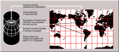
Condensed explanation of Mercator-projection maps, converted to SVG format from larger USGS file of GIF format. See enlarged view below, using a wikitable to expand beyond original size. |
|---|---|
| Source |
derivative from USGS image file,
|
| Date |
February 2005 |
| Author |
derived from US Government USGS |
| Permission ( Reusing this image) |
(see below)
|
Enlarged view
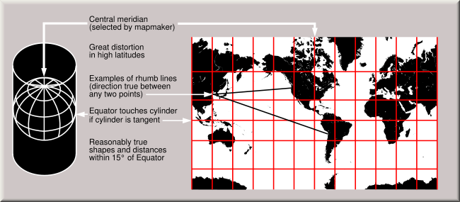 The Mercator projection shows courses of constant bearing as straight lines. While common, scholars advise against using it for reference maps of the world because it drastically inflates the high latitudes. |
Licensing
 |
I, the copyright holder of this work, hereby release it into the public domain. This applies worldwide. In case this is not legally possible: Afrikaans | Alemannisch | Aragonés | العربية | Asturianu | Български | Català | Cebuano | Česky | Cymraeg | Dansk | Deutsch | Eʋegbe | Ελληνικά | English | Español | Esperanto | Euskara | Estremeñu | فارسی | Français | Galego | 한국어 | हिन्दी | Hrvatski | Ido | Bahasa Indonesia | Íslenska | Italiano | עברית | Kurdî / كوردی | Latina | Lietuvių | Latviešu | Magyar | Македонски | Bahasa Melayu | Nederlands | Norsk (bokmål) | Norsk (nynorsk) | 日本語 | Polski | Português | Ripoarisch | Română | Русский | Shqip | Slovenčina | Slovenščina | Српски / Srpski | Suomi | Svenska | ไทย | Tagalog | Türkçe | Українська | Tiếng Việt | Walon | 中文(简体) | 中文(繁體) | zh-yue-hant | +/- |
File history
Click on a date/time to view the file as it appeared at that time.
| Date/Time | Dimensions | User | Comment | |
|---|---|---|---|---|
| current | 16:41, 19 August 2006 | 413×181 (525 KB) | Wereon | (Vectorization of USGS image ([http://erg.usgs.gov/isb/pubs/MapProjections/projections.html World map projections]). Shoreline data from GSHHS, a public-domain data source. Category:USGS projections) |